IMAGES TAKEN NEAR TO
Huttock End Lane, BACUP, OL13 8LT
Introduction
This page details the photographs taken nearby to Huttock End Lane, OL13 8LT by members of the Geograph project.
The Geograph project started in 2005 with the aim of publishing, organising and preserving representative images for every square kilometre of Great Britain, Ireland and the Isle of Man.

There are currently over 7.5m images from over14,400 individuals and you can help contribute to the project by visiting https://www.geograph.org.uk
Image Map
Images are licensed for reuse under creativecommons.org/licenses/by-sa/2.0
Notes
- Clicking on the map will re-center to the selected point.
- The higher the marker number, the further away the image location is from the centre of the postcode.
Image Listing (94 Images Found)
Images are licensed for reuse under creativecommons.org/licenses/by-sa/2.0
Image
Details
Distance
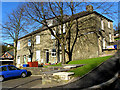
1
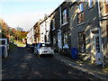
Bacup: Ormerod's Buildings, Stacksteads
This block was originally built as back-to-back houses.
Image: © Dr Neil Clifton
Taken: 10 Nov 2010
0.03 miles
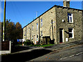
2
Bacup: Marshall's Buildings, Stacksteads
Originally built as one of three blocks of back-to-back houses, but the middle block, known as Brick Buildings, was demolished years ago, giving a pleasant spacious aspect to the other two rows. Some of these have been knocked through to make single dwellings.
Image: © Dr Neil Clifton
Taken: 10 Nov 2010
0.03 miles
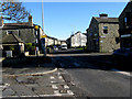
3
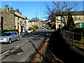
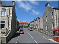
Bacup: Huttock End Lane, Stacksteads
Looking north from the junction with Newchurch Road
Image: © Dr Neil Clifton
Taken: 10 Nov 2010
0.03 miles
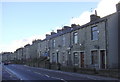
4
Bacup: Huttock End Lane, Stacksteads
Image: © Dr Neil Clifton
Taken: 10 Nov 2010
0.06 miles
5
Bacup: Bankfield Street, Stacksteads
Looking north. This street was formerly known as Sandhole Row. The street is unmade, and there is no vehicular exit at the north end. The houses seen here are numbered from 17 to 31 (odds). There are no houses on the other side.
Image: © Dr Neil Clifton
Taken: 10 Nov 2010
0.06 miles
6
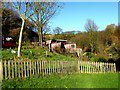
Bacup: Allotments at the north end of Bankfield Street, Stacksteads
Looking north. Some of the sheds are used for keeping birds, etc.
Image: © Dr Neil Clifton
Taken: 10 Nov 2010
0.08 miles
7
Newchurch Road Stacksteads.
A681 towards Rawtenstall. Booth Road branches away to the right.
Image: © Robert Wade
Taken: 24 Jul 2007
0.08 miles
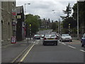
8
Bacup: Newchurch Road, Stacksteads
Looking east, towards Bacup,from the end of Booth Road at the point sometimes known as Stackteads Bar. The road is part of the A681.
Image: © Dr Neil Clifton
Taken: 10 Nov 2010
0.08 miles
9
Hindle Street Stacksteads
Hindle Street is on a steep hill just off Newchurch Road in Stacksteads.
At the top of the street on the right the property for sale is a 4 bedroom
semi-detached stone house which (for future reference) was on the market
for £139,950 in July 2008
Image: © Paul Anderson
Taken: 21 Jul 2008
0.09 miles
10
Terraced Housing, Newchurch Road
There has been an improvement scheme with sandblasting, pointing etc
Image: © Robert Wade
Taken: 24 Jan 2009
0.10 miles