IMAGES TAKEN NEAR TO
Royds Road, BACUP, OL13 0PG
Introduction
This page details the photographs taken nearby to Royds Road, OL13 0PG by members of the Geograph project.
The Geograph project started in 2005 with the aim of publishing, organising and preserving representative images for every square kilometre of Great Britain, Ireland and the Isle of Man.

There are currently over 7.5m images from over14,400 individuals and you can help contribute to the project by visiting https://www.geograph.org.uk
Image Map
Images are licensed for reuse under creativecommons.org/licenses/by-sa/2.0
Notes
- Clicking on the map will re-center to the selected point.
- The higher the marker number, the further away the image location is from the centre of the postcode.
Image Listing (39 Images Found)
Images are licensed for reuse under creativecommons.org/licenses/by-sa/2.0
Image
Details
Distance
2
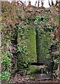
Vertical Culvert in Railway Cutting
This appears to be a drain from the hillside which has required substantial masonry. Near Waterbarn Mills
Image: © Kevin Waterhouse
Taken: 14 Apr 2021
0.08 miles
3
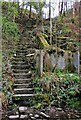
Steps in Railway Cutting near Waterbarn Mill
The railway presumably had hillside water drainage problems and needed to climb out of the cutting. Old OS maps have a tank marked about here.
Image: © Kevin Waterhouse
Taken: 14 Apr 2021
0.08 miles
4
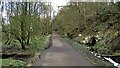
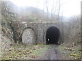
Cyclepath East of Thrutch Tunnel
Cyclepath view East along former railway towards Bacup. It is contoured in the hillside above the River Irwell at this point
Image: © Kevin Waterhouse
Taken: 14 Apr 2021
0.08 miles
6
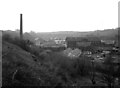
The end of an era at Stacksteads, Lancashire
The icy winds of change had begun to blow through Lancashire's Rossendale Valley long before this 1976 photograph was taken. The derelict trackbed of the railway can be seen, right foreground, its metals long removed, courtesy of Beeching. Almost all the industrial buildings in the picture are disused or derelict, the post-war textile boom already over.
Image: © Dr Neil Clifton
Taken: 15 Apr 1976
0.12 miles
7
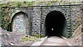
Cyclepath through Newchurch No.2 Tunnel
View West on newly laid cyclepath with the blocked Thrutch Tunnel to the left
Image: © Kevin Waterhouse
Taken: 14 Apr 2021
0.13 miles