IMAGES TAKEN NEAR TO
Birch Road, ROCHDALE, OL12 9QB
Introduction
This page details the photographs taken nearby to Birch Road, OL12 9QB by members of the Geograph project.
The Geograph project started in 2005 with the aim of publishing, organising and preserving representative images for every square kilometre of Great Britain, Ireland and the Isle of Man.

There are currently over 7.5m images from over14,400 individuals and you can help contribute to the project by visiting https://www.geograph.org.uk
Image Map (Loading...)


Getting Data...Please wait
Leaflet Map data © OpenStreetMap
Images are licensed for reuse under creativecommons.org/licenses/by-sa/2.0
Notes
- Clicking on the map will re-center to the selected point.
- The higher the marker number, the further away the image location is from the centre of the postcode.
Image Listing (36 Images Found)
Images are licensed for reuse under creativecommons.org/licenses/by-sa/2.0
Image
Details
Distance
1
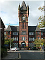
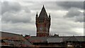
Birch Hill Clock Tower
This is what's left of Birch Hill Hospital. Most of the services have been moved to the Rochdale Infirmary. The services still at Birch Hill include E.N.T. and the eye department.
Image: © Jeff Mills
Taken: 9 Oct 2004
0.00 miles
2
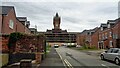
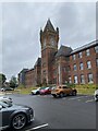
Birch Hill Clock Tower Block Conversion
The former workhouse and hospital has had housing built in its grounds and at least the Clock Tower block converted to apartments. This view in Union Road shows some of the old workhouse walling and gatepost as well as new houses.
Image: © Kevin Waterhouse
Taken: 12 Jul 2016
0.01 miles
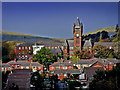
5
Birch Hill Clock Tower
The former workhouse and latterly hospital undergoing conversion to housing
Image: © Kevin Waterhouse
Taken: 12 Jul 2016
0.02 miles
7
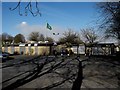
St Andrew's School, Dearnley
The school was built in the 1970s to replace the similarly named Church of England school that was situated on School Street on the other (east) side of Saint Andrew's church. The school day has ended and the shutters are drawn down on the windows and doors.
Saint Andrew's CE Primary School website: http://www.clc2.uniservity.com/Grouphomepage.asp?GroupId=392834
Saint Andrew's church website: http://www.standrewsdearnley.co.uk/
Image: © Peter Thwaite
Taken: 22 Apr 2010
0.10 miles
8
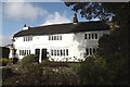
Dearnley Old Hall
Grade II* listed building, probably early to mid 17C:
British Listed Buildings description: http://www.britishlistedbuildings.co.uk/en-213381-dearnley-old-hall-
Image: © Peter Thwaite
Taken: 17 Oct 2014
0.14 miles
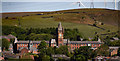
9
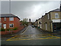
Union Road, Wardle
A view up Union Road in Wardle, Greater Manchester, England. The ornate building at the top of the road is Birch Hill Hospital, what was originally the Dearnley Union Workhouse.
Image: © Steven Haslington
Taken: 26 May 2011
0.15 miles
10
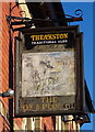
Faded sign for the Ox & Plough, Hurstead, Littleborough
Reverse of Image]
Image: © JThomas
Taken: 18 Oct 2018
0.16 miles