IMAGES TAKEN NEAR TO
Greenlees Street, ROCHDALE, OL12 0NG
Introduction
This page details the photographs taken nearby to Greenlees Street, OL12 0NG by members of the Geograph project.
The Geograph project started in 2005 with the aim of publishing, organising and preserving representative images for every square kilometre of Great Britain, Ireland and the Isle of Man.

There are currently over 7.5m images from over14,400 individuals and you can help contribute to the project by visiting https://www.geograph.org.uk
Image Map (Loading...)


Getting Data...Please wait
Leaflet Map data © OpenStreetMap
Images are licensed for reuse under creativecommons.org/licenses/by-sa/2.0
Notes
- Clicking on the map will re-center to the selected point.
- The higher the marker number, the further away the image location is from the centre of the postcode.
Image Listing (100 Images Found)
Images are licensed for reuse under creativecommons.org/licenses/by-sa/2.0
Image
Details
Distance
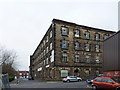
4
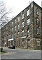
Duke Street Mill, Rochdale
Mid to late 19th century, with stone facades to Queen Street and Duke street, although the principal build material is brick. The grey building is the former Mount Pleasant Inn. Between it and the main mill is the engine house for the mill, with a blocked tall round-headed window. This would probably have housed a beam engine.
Image: © Alan Murray-Rust
Taken: 8 Apr 2022
0.06 miles
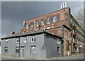
5
Duke Street Mill, Rochdale
Mid to late 19th century, with stone facades to Queen Street and Duke street, although the principal build material is brick.
Image: © Alan Murray-Rust
Taken: 8 Apr 2022
0.07 miles
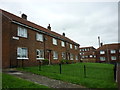
8
Old Mill Street, Rochdale
Social housing very close to Rochdale's town centre. Looking northwest from the junction with High Street, a road that runs parallel with St Mary's Gate.
Image: © michael ely
Taken: 24 Nov 2008
0.10 miles
9
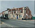
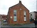
The former Globe Inn, Whitworth Road, Rochdale
One of the few local examples of early 20th century (?1920s) terracotta facading and decoration. Since 2014 in use as a veterinary surgery.
Image: © Alan Murray-Rust
Taken: 8 Apr 2022
0.10 miles
10
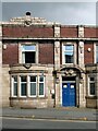
The former Globe Inn, Whitworth Road, Rochdale
Part view of main front with terracotta detailing. See https://www.geograph.org.uk/photo/7147716 for location.
Image: © Alan Murray-Rust
Taken: 8 Apr 2022
0.10 miles