IMAGES TAKEN NEAR TO
Furbarn Road, ROCHDALE, OL11 5QR
Introduction
This page details the photographs taken nearby to Furbarn Road, OL11 5QR by members of the Geograph project.
The Geograph project started in 2005 with the aim of publishing, organising and preserving representative images for every square kilometre of Great Britain, Ireland and the Isle of Man.

There are currently over 7.5m images from over14,400 individuals and you can help contribute to the project by visiting https://www.geograph.org.uk
Image Map
Images are licensed for reuse under creativecommons.org/licenses/by-sa/2.0
Notes
- Clicking on the map will re-center to the selected point.
- The higher the marker number, the further away the image location is from the centre of the postcode.
Image Listing (8 Images Found)
Images are licensed for reuse under creativecommons.org/licenses/by-sa/2.0
Image
Details
Distance
1
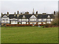
Scott House
Scott House hospital, Furbarn Road.Part of the Calderstones Partnership NHS Foundation Trust.
Image: © David Dixon
Taken: 26 Jan 2010
0.05 miles
2
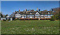
Scott House
An NHS care home in Norden.
Image: © Peter McDermott
Taken: 18 Apr 2014
0.06 miles
3
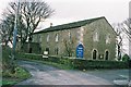
St James' Church, Ashworth, Rochdale, Lancashire
The church, believed to have been founded C1514 and in the patronage of Lord Egerton, has been known locally for many years, as Ashworth Chapel. http://www.genuki.org.uk/big/eng/LAN/Ashworth/ The nearby public house, which is the Egerton Arms is known as "Ashworth Chapel House."
Image: © Dr Neil Clifton
Taken: 22 Mar 2004
0.21 miles
5
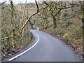
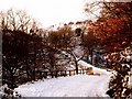
School Lane
View looking down school lane.
Image: © David Dixon
Taken: 26 Jan 2010
0.22 miles
6
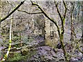
Higher Clough, mill remains.
The remains of a disused mill. The area is now completely overgrown by trees which hide the ruins from view when they are in leaf during the spring and summer months.
Image: © David Dixon
Taken: 26 Jan 2010
0.23 miles
7
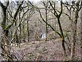
Higher Clough
Higher Clough, Ashworth Valley.
Image: © David Dixon
Taken: 26 Jan 2010
0.24 miles
8

Naden Brook
Naden Brook passing the ruined remains of an old mill which presumably once drew water from the brook. The ruins are now overgrown by trees whose leaves hide it from view during the summer months.
Image: © David Dixon
Taken: 26 Jan 2010
0.24 miles