IMAGES TAKEN NEAR TO
Blackpits Road, ROCHDALE, OL11 5NG
Introduction
This page details the photographs taken nearby to Blackpits Road, OL11 5NG by members of the Geograph project.
The Geograph project started in 2005 with the aim of publishing, organising and preserving representative images for every square kilometre of Great Britain, Ireland and the Isle of Man.

There are currently over 7.5m images from over14,400 individuals and you can help contribute to the project by visiting https://www.geograph.org.uk
Image Map
Images are licensed for reuse under creativecommons.org/licenses/by-sa/2.0
Notes
- Clicking on the map will re-center to the selected point.
- The higher the marker number, the further away the image location is from the centre of the postcode.
Image Listing (69 Images Found)
Images are licensed for reuse under creativecommons.org/licenses/by-sa/2.0
Image
Details
Distance
2
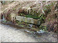
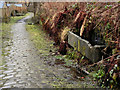
Stone trough on the side of the old access road to Blackpits Mill
Image: © Alexander P Kapp
Taken: 1 Feb 2010
0.02 miles
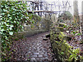
3
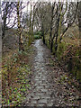
Footpath, near Blackpit Mill
This is probably the old access road to Blackpit Mill
Image: © Alexander P Kapp
Taken: 1 Feb 2010
0.02 miles
4
Pack Horse Track Behind Blackpits Road
The old pack horse route to Blackpits Mill, with the stone water trough at the side.
Image: © David Dixon
Taken: 5 Jan 2011
0.02 miles
5
Footpath off the old access road to Blackpit Mill
Image: © Alexander P Kapp
Taken: 1 Feb 2010
0.03 miles
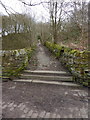
6
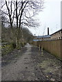
Cobbled Track to Blackpits
After leaving Image], the track continues towards Blackpits.
Image: © David Dixon
Taken: 5 Jan 2011
0.04 miles
7
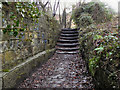
Footpath Steps
The steps near Image] on the track to Blackpits.
Image: © David Dixon
Taken: 5 Jan 2011
0.05 miles
8
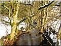
Naden Brook
Naden Brook passing through Norden. Taken just South of The A680 Edenfield Road
Image: © David Dixon
Taken: 12 Jan 2010
0.06 miles
9
Clearing
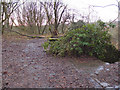
When Image] reaches this clearing, the path splits. To the right the path descends the side of the hill towards Blackpits. Straight ahead, the path stays near the top of the hill before dropping to Naden Brook at Coal Bank. There are a few remains of a stone building behind, and below, the bush where the path splits.
Image: © David Dixon
Taken: 5 Jan 2011
0.06 miles
10
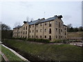
New housing on the site of Blackpits Mill
Image: © Alexander P Kapp
Taken: 1 Feb 2010
0.06 miles