IMAGES TAKEN NEAR TO
Nicholson Street, ROCHDALE, OL11 1PT
Introduction
This page details the photographs taken nearby to Nicholson Street, OL11 1PT by members of the Geograph project.
The Geograph project started in 2005 with the aim of publishing, organising and preserving representative images for every square kilometre of Great Britain, Ireland and the Isle of Man.

There are currently over 7.5m images from over14,400 individuals and you can help contribute to the project by visiting https://www.geograph.org.uk
Image Map
Images are licensed for reuse under creativecommons.org/licenses/by-sa/2.0
Notes
- Clicking on the map will re-center to the selected point.
- The higher the marker number, the further away the image location is from the centre of the postcode.
Image Listing (149 Images Found)
Images are licensed for reuse under creativecommons.org/licenses/by-sa/2.0
Image
Details
Distance
1
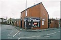
Shop, Milkstone Road, Deeplish, Rochdale, Lancashire
This small shop, now an electrical suppliers', was formerly a butcher's shop where the butcher's boy was provided with a bicycle with solid tyres. Overt Street Baptist Church Image is seen in the background.
Image: © Dr Neil Clifton
Taken: 22 Mar 2004
0.04 miles
2
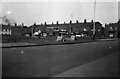
Shopping parade, Milkstone Road, Rochdale, Lancashire
It's 1955, and a plume of smoke rises from a locomotive on Rochdale station as an office worker makes his way home across waste ground on the corner of Ashfield Road and Milkstone Road. Also visible on the extreme left is the Brown Cow public house.
Image: © Dr Neil Clifton
Taken: 15 Apr 1955
0.04 miles
3
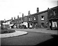
Shopping parade, Milkstone Road, Rochdale, Lancashire
By the time of this photograph in 1964, this part of Rochdale had become a rather cleaner place, probably because most of the steam locomotives on the nearby railway had been replaced by diesels. The Brown Cow public house is seen here on the extreme left.
Image: © Dr Neil Clifton
Taken: 25 Aug 1964
0.04 miles
4
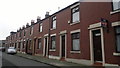
Aubrey Street, Rochdale
A row of red-brick terraced houses on Aubrey Street in Rochdale, Greater Manchester, England. Such housing stock is typical of much of Rochdale and of Greater Manchester.
Image: © Steven Haslington
Taken: 11 Nov 2011
0.05 miles
5
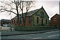
Baptist Church, Overt Street, Deeplish, Rochdale Lancashire.
Unlike many smaller nonconformist churches, which have 'gone under', this one is still holding its own in an area mainly occupied by people of New Commonwealth origin.
Image: © Dr Neil Clifton
Taken: 22 Mar 2004
0.07 miles
7
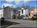
Rochdale: 146 Vine Place
Almost all the property on this patch of ground just west of Milkstone Road and south of the railway was demolished over 50 years ago, and there has been a large amount of new building. But the group of properties shown here survives from the late Victorian era. It includes, on the extreme left, a house whose address is 146, Vine Place. The number is still proudly displayed on the door, even though every other house in Vine Place had vanished before 1950.
Image: © Dr Neil Clifton
Taken: 18 Mar 2011
0.07 miles
8
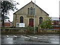
Zion Baptist Church, Milkstone Road, Rochdale
Image: © Ian S
Taken: 11 Sep 2010
0.07 miles
9
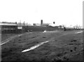
Waste Ground outside Riley's Spring Works
I celebrated my 21st birthday by taking this photograph of waste ground outside the spring works. In those days. nobody bothered about air pollution. Engines would stand on the sidings for hours emitting smoke and steam, while additional smoke was caused by Riley's workmen setting fire to waste rubber outside the works.
Image: © Dr Neil Clifton
Taken: 4 Jun 1956
0.08 miles
10
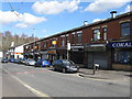
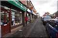
Rochdale: Shops on Milkstone Road
This parade of local shops is beginning to suffer from closures as out-of-town shopping with the car takes away more and more trade. At the far left hand en is seen what once was the 'Brown Cow' public house - now itself closed and converted into a 'minimart'.
Image: © Dr Neil Clifton
Taken: 18 Mar 2011
0.08 miles