IMAGES TAKEN NEAR TO
Pomona Street, ROCHDALE, OL11 1PD
Introduction
This page details the photographs taken nearby to Pomona Street, OL11 1PD by members of the Geograph project.
The Geograph project started in 2005 with the aim of publishing, organising and preserving representative images for every square kilometre of Great Britain, Ireland and the Isle of Man.

There are currently over 7.5m images from over14,400 individuals and you can help contribute to the project by visiting https://www.geograph.org.uk
Image Map
Images are licensed for reuse under creativecommons.org/licenses/by-sa/2.0
Notes
- Clicking on the map will re-center to the selected point.
- The higher the marker number, the further away the image location is from the centre of the postcode.
Image Listing (66 Images Found)
Images are licensed for reuse under creativecommons.org/licenses/by-sa/2.0
Image
Details
Distance
1
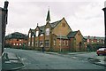
St. Luke's Church, Salkeld Street, Deeplish, Rochdale, Lancashire
This building was formerly the Sunday School of St. Luke's: the actual Church building stood a short distance further away from the photographer, on Deeplish Road. But in the 1980s the large Church itself was sold for demolition and replaced by the modern flats visible in the left background of the photograph. Services were then transferred to the Sunday School building shown above, which thus became the Church.
Image: © Dr Neil Clifton
Taken: 22 Mar 2004
0.07 miles
2
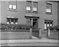
Rochdale, Lancashire: Terrace houses on Deeplish Road
No 86 on the right with the door open, and No 88, where I lived as a boy from 1948 to 1954.
Image: © Dr Neil Clifton
Taken: 18 Jun 1949
0.11 miles
3
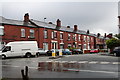
Deeplish Road, Rochdale, Lancashire
Looking eastwards from the junction of Deeplish Road with Ashfield Road, known locally as Deeplish Corner. These are large terrace houses which each have, or had, a small front garden: however, some of these front gardens have been removed to create space to keep a m***r c*r, (that affliction of our villages, towns and cities!)
Image: © Dr Neil Clifton
Taken: 9 Jul 2007
0.11 miles
4
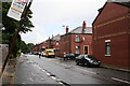
Ashfield Road, Rochdale, Lancashire
This is looking northwards from Deeplish Corner, and shows the junctions of Ashfield Road with Ventnor Street and Aubrey Street. The decorative brickwork on the terrace ends is of recent origin. The tilting bus stop sign is of significance - it states 'out of use'. There is no bus service whatever now into the Deeplish district. Interestingly enough, this is the route of Rochdale Corporation's very first bus service. Back in the 1920s, the corporation was a tramway operator, but trams would not have been suitable in Deeplish with its narrow roads and awkward street layout. So a motorbus service was started, and appropriately enough, was given service No 1. It ran for very many years, usually at a 10 minute frequency, surviving into the SELNEC and GMPTE eras (although renumbered). But now it has gone with only a few disused bus stops to recall its existence.
Image: © Dr Neil Clifton
Taken: 9 Jul 2007
0.11 miles
5
Deeplish Road, Rochdale
No 86 (nearest house) and No 88 have had front gardens removed: passage between 86 and 84 illegally gated and locked: road humps (unnecessary on this curving road) will mitigate against reintroduction of bus service.
Image: © Dr Neil Clifton
Taken: 9 Jul 2007
0.11 miles
6
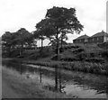
Rochdale Canal
The houses visible in the background were then in local authority ownership: those on the right in Digby Road, and those on the extreme left in Dicken Green.
Although the water looks clear, the Rochdale Canal was not navigable at that time.
Image: © Dr Neil Clifton
Taken: 3 Sep 1954
0.12 miles
7
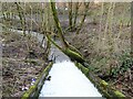
Sudden Brook
The overspill from the Rochdale Canal discharges into Sudden Brook, a tributary of the River Roch.
Image: © michael ely
Taken: 13 Mar 2021
0.13 miles
8

Rochdale Canal, between bridges 61 and 62
Seen from the front of a narrowboat heading south-west towards Manchester.
Image: © Christine Johnstone
Taken: 7 May 2014
0.13 miles
9
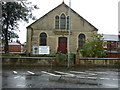
Zion Baptist Church, Milkstone Road, Rochdale
Image: © Ian S
Taken: 11 Sep 2010
0.14 miles
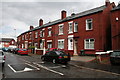
10
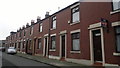
Aubrey Street, Rochdale
A row of red-brick terraced houses on Aubrey Street in Rochdale, Greater Manchester, England. Such housing stock is typical of much of Rochdale and of Greater Manchester.
Image: © Steven Haslington
Taken: 11 Nov 2011
0.14 miles