IMAGES TAKEN NEAR TO
Cedar Avenue, HEYWOOD, OL10 4UJ
Introduction
This page details the photographs taken nearby to Cedar Avenue, OL10 4UJ by members of the Geograph project.
The Geograph project started in 2005 with the aim of publishing, organising and preserving representative images for every square kilometre of Great Britain, Ireland and the Isle of Man.

There are currently over 7.5m images from over14,400 individuals and you can help contribute to the project by visiting https://www.geograph.org.uk
Image Map
Images are licensed for reuse under creativecommons.org/licenses/by-sa/2.0
Notes
- Clicking on the map will re-center to the selected point.
- The higher the marker number, the further away the image location is from the centre of the postcode.
Image Listing (36 Images Found)
Images are licensed for reuse under creativecommons.org/licenses/by-sa/2.0
Image
Details
Distance
1
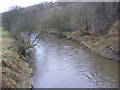
River Roch
Facing North East from the bridge at Bottom O' th' Brow
Image: © Paul Hogg
Taken: 19 Jan 2008
0.17 miles
2
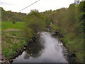
River Roch
Looking upstream from the bridge at Bottom O'Th' Brow.
Image: © David Dixon
Taken: 7 May 2010
0.18 miles

4
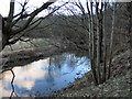
River Roch
A stretch of the River Roch below Bottom'o'th'Brow and the disused workings along the bank.
Image: © Roger May
Taken: 28 Feb 2006
0.19 miles

6
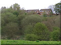
Back of Thorn Close
Houses on Thorn Close, at the top of the steep side of the valley at Bottom O'Th' Brow.
Image: © David Dixon
Taken: 7 May 2010
0.20 miles
8
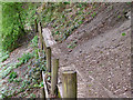
Riverside path
Path cut into the steep valley slope on the southern side of the River Roch at Bottom O'Th' Brow.
Image: © David Dixon
Taken: 7 May 2010
0.20 miles
9
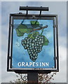
Sign for the Grapes Inn public house, Heywood
Image: © JThomas
Taken: 17 Sep 2018
0.21 miles
10

The Grapes Inn, Back O 'th' Moss
One of two Sam Smith's public houses in Heywood.
Image: © Ian S
Taken: 10 Jul 2012
0.21 miles