IMAGES TAKEN NEAR TO
Durham Walk, HEYWOOD, OL10 3HS
Introduction
This page details the photographs taken nearby to Durham Walk, OL10 3HS by members of the Geograph project.
The Geograph project started in 2005 with the aim of publishing, organising and preserving representative images for every square kilometre of Great Britain, Ireland and the Isle of Man.

There are currently over 7.5m images from over14,400 individuals and you can help contribute to the project by visiting https://www.geograph.org.uk
Image Map (Loading...)


Getting Data...Please wait
Leaflet Map data © OpenStreetMap
Images are licensed for reuse under creativecommons.org/licenses/by-sa/2.0
Notes
- Clicking on the map will re-center to the selected point.
- The higher the marker number, the further away the image location is from the centre of the postcode.
Image Listing (14 Images Found)
Images are licensed for reuse under creativecommons.org/licenses/by-sa/2.0
Image
Details
Distance
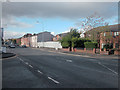
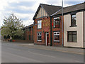
1

Wham Street
At the junction with Bury Street, Heywood. The Horse and Jockey public house is only one of many such establishments along this road to supply refreshment for the carters before or after the climb to Prettywood summit.
Image: © Dennis Turner
Taken: 9 Nov 2005
0.02 miles
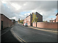
2
Wham Bar
Road junction between Heywood and Bury. View towards Summit of Prettywood Brow, on Bury New Road.
Image: © Dennis Turner
Taken: 9 Nov 2005
0.06 miles
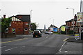
3
Bury Old Road. Heywood
Superseded by Bury New Road, the A58, which is more direct.
Image: © Bill Boaden
Taken: 26 Jul 2012
0.09 miles
4
Bury Street, Heywood
Looking in the direction of the town centre. The lettering on the side of the Horse and Jockey has dropped off but it is still open.
Image: © Bill Boaden
Taken: 26 Jul 2012
0.10 miles
5

Bury Old and New Roads
The Junction of Bury Old Road with Bury New Road (A58)
Image: © David Dixon
Taken: 7 May 2010
0.10 miles
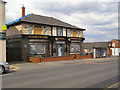
6
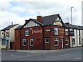
Heywood: The 'Horse and Jockey'
Thankfully the 'Jockey' is still open. Everyone is aware that pubs are closing all over the country. What is not so well-known is the fact that in Lancashire and Yorkshire former mill-towns, the loss can be over 60% and up to 80% is some grid squares, (SD 8912 in Rochdale, for example).
Image: © Dr Neil Clifton
Taken: 2 Jun 2013
0.11 miles
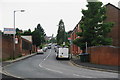
7

Approaching the centre of Heywood
The A58 runs through the town. The spire in the distance is that of St. Luke's church, a Church of England parish church.
Image: © philandju
Taken: 7 Aug 2017
0.11 miles
8
Horse and Jockey
Bury Street, at the corner of Wham Street.
Image: © David Dixon
Taken: 7 May 2010
0.11 miles
9
Towards Heady Hill
View from Wham Bar along the old road from Heywood to Bury. The wall on the left is from the remains of a former textile mill.
Image: © Dennis Turner
Taken: 9 Nov 2005
0.12 miles
10
Stonemasons Arms
Bury Street, at the corner with Mason Street.
Image: © David Dixon
Taken: 7 May 2010
0.16 miles