IMAGES TAKEN NEAR TO
Rochdale Road East, HEYWOOD, OL10 1RL
Introduction
This page details the photographs taken nearby to Rochdale Road East, OL10 1RL by members of the Geograph project.
The Geograph project started in 2005 with the aim of publishing, organising and preserving representative images for every square kilometre of Great Britain, Ireland and the Isle of Man.

There are currently over 7.5m images from over14,400 individuals and you can help contribute to the project by visiting https://www.geograph.org.uk
Image Map (Loading...)


Getting Data...Please wait
Leaflet Map data © OpenStreetMap
Images are licensed for reuse under creativecommons.org/licenses/by-sa/2.0
Notes
- Clicking on the map will re-center to the selected point.
- The higher the marker number, the further away the image location is from the centre of the postcode.
Image Listing (15 Images Found)
Images are licensed for reuse under creativecommons.org/licenses/by-sa/2.0
Image
Details
Distance
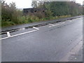
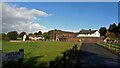
2
Rochdale Road East (A58)
Looking north east.
Image: © JThomas
Taken: 25 Sep 2018
0.02 miles
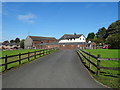
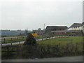
4
Primrose Hill Farm
Withs its new access road from Rochdale Road East
Image: © Kevin Waterhouse
Taken: 10 Oct 2022
0.06 miles
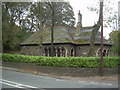
6
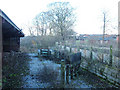
Sheep pens, derelict urban farm, Heywood
Little Bo-Peep has lost her sheep. This farm is still shown on the 1/50,000 OS map as a tourist attraction. Urban farms were used to introduce inner-city children to farm animals and to educate them about the source of their food.
Image: © michael ely
Taken: 6 Dec 2005
0.10 miles
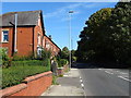
7
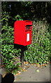
Elizabeth II postbox on Rochdale Road East
Image: © JThomas
Taken: 25 Sep 2018
0.10 miles
8
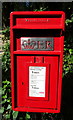
Close up, Elizabeth II postbox on Rochdale Road East
Postbox No. OL10 173.
See Image] for wider view.
Image: © JThomas
Taken: 25 Sep 2018
0.10 miles
9
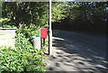
Rochdale Road East
Looking north east on the A58 showing position of Postbox No. OL10 173.
See Image] for postbox.
Image: © JThomas
Taken: 25 Sep 2018
0.10 miles