IMAGES TAKEN NEAR TO
Church Lane, LONDON, NW9 8JS
Introduction
This page details the photographs taken nearby to Church Lane, NW9 8JS by members of the Geograph project.
The Geograph project started in 2005 with the aim of publishing, organising and preserving representative images for every square kilometre of Great Britain, Ireland and the Isle of Man.

There are currently over 7.5m images from over14,400 individuals and you can help contribute to the project by visiting https://www.geograph.org.uk
Image Map
Images are licensed for reuse under creativecommons.org/licenses/by-sa/2.0
Notes
- Clicking on the map will re-center to the selected point.
- The higher the marker number, the further away the image location is from the centre of the postcode.
Image Listing (115 Images Found)
Images are licensed for reuse under creativecommons.org/licenses/by-sa/2.0
Image
Details
Distance
1
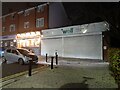
Well Pharmacy on Church Lane, Kingsbury
This belonged to the Co-op till they sold their chemists recently.
Image: © David Howard
Taken: 1 Dec 2022
0.00 miles
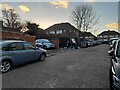
2
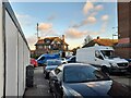
Merley Court, Kingsbury
Looking towards Church Lane
Image: © David Howard
Taken: 5 Jan 2022
0.01 miles
3
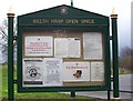
The Welsh Harp Reservoir
This car park is at the western end of the Welsh Harp Reservoir.
Image: © Robert Timms
Taken: 28 Mar 2006
0.01 miles
4
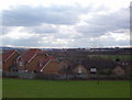
View from the Silver Jubilee Park
This shows the view from the high point of the park with new houses in the centre. The post Office tower about 8 miles away on the horizon.
The parkland behind the houses is part of the Welsh Harp Nature Reserve.
Image: © Robert Timms
Taken: 3 Apr 2006
0.01 miles
5
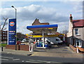
Gulf Petrol Station
The Gulf Petrol Station at the junction of Wood Lane and Church Lane, has been refitted with an extended shop. All signs etc only a few months old.
Image: © Robert Timms
Taken: 6 Apr 2006
0.01 miles
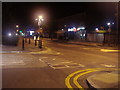
7
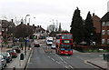
Church Lane
Seen at the junction with Mallard Way, looking towards the mini-roundabout at the Wood Lane junction. The view is taken from the upper deck of a number 83 bus en-route from Golders Green to Ealing Hospital. Going the other way is a Metroline operated number 302 en-route to Mill Hill Broadway from Kensal Rise. The vehicle is a Volvo B7TL with a Transbus President body.
Image: © Martin Addison
Taken: 26 Dec 2011
0.01 miles
10
Shops on Church Lane, Kingsbury
There's a Co-operative on the left with their chemist and funeral director next door which has been here longer than me (1960 originally), and had a bank at the front of the shop to begin with as well. The Pied Piper shop opposite towards the left has also been there since before 1960 although under different ownership. There's also a newsagent behind the Co-op at least, while a few other shops have only changed in the last ten years or so which were there since before 1960.
Image: © David Howard
Taken: 23 Jul 2013
0.02 miles