IMAGES TAKEN NEAR TO
Acklington Drive, LONDON, NW9 5WL
Introduction
This page details the photographs taken nearby to Acklington Drive, NW9 5WL by members of the Geograph project.
The Geograph project started in 2005 with the aim of publishing, organising and preserving representative images for every square kilometre of Great Britain, Ireland and the Isle of Man.

There are currently over 7.5m images from over14,400 individuals and you can help contribute to the project by visiting https://www.geograph.org.uk
Image Map (Loading...)


Getting Data...Please wait
Leaflet Map data © OpenStreetMap
Images are licensed for reuse under creativecommons.org/licenses/by-sa/2.0
Notes
- Clicking on the map will re-center to the selected point.
- The higher the marker number, the further away the image location is from the centre of the postcode.
Image Listing (10 Images Found)
Images are licensed for reuse under creativecommons.org/licenses/by-sa/2.0
Image
Details
Distance
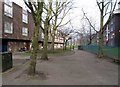
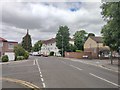
5
Heybourne Crescent at the junction of Lanacre Avenue
Image: © David Howard
Taken: 2 Mar 2021
0.18 miles
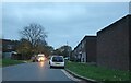
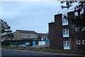
7
Lanacre Avenue - Burnt Oak
Road cross junction with Angus Gardens and Pageant Avenue.
Image: © James Emmans
Taken: 13 May 2020
0.21 miles
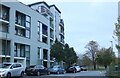
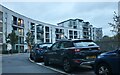
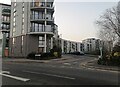
8
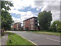
Lanacre Avenue
Modern residential flats.
Image: © James Emmans
Taken: 13 May 2020
0.21 miles