IMAGES TAKEN NEAR TO
Heybourne Crescent, LONDON, NW9 5UW
Introduction
This page details the photographs taken nearby to Heybourne Crescent, NW9 5UW by members of the Geograph project.
The Geograph project started in 2005 with the aim of publishing, organising and preserving representative images for every square kilometre of Great Britain, Ireland and the Isle of Man.

There are currently over 7.5m images from over14,400 individuals and you can help contribute to the project by visiting https://www.geograph.org.uk
Image Map
Images are licensed for reuse under creativecommons.org/licenses/by-sa/2.0
Notes
- Clicking on the map will re-center to the selected point.
- The higher the marker number, the further away the image location is from the centre of the postcode.
Image Listing (16 Images Found)
Images are licensed for reuse under creativecommons.org/licenses/by-sa/2.0
Image
Details
Distance
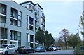
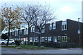
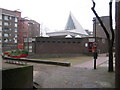
3
Heybourne Crescent at the junction of Lanacre Avenue
Image: © David Howard
Taken: 2 Mar 2021
0.07 miles
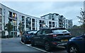
6
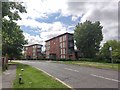
Lanacre Avenue
Modern residential flats.
Image: © James Emmans
Taken: 13 May 2020
0.17 miles
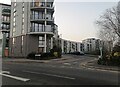
7
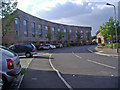
Kenley Avenue, Grahame Park
This is part of a new development replacing some of the original council blocks on Grahame Park in the late 2000s
Image: © David Howard
Taken: 18 Sep 2008
0.18 miles
8
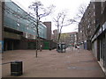
Grahame Park: The Concourse, NW9
Grahame Park was built by the GLC in the 1970s and is the London Borough of Barnet's largest housing estate with 1,777 homes. The planning of the estate has isolated it from outside areas, but redevelopment plans have been drawn up to regenerate the area by reorientating the estate and constructing 3,000 more homes over the next 15 years, it says here http://www.barnet.gov.uk/regeneration-grahame-park
However the social problems are many and the licence of the Hind and Hart public house, visible on the left, was suspended in February 2007 by the local council after the police called for a review, citing a string of incidents at the pub involving firearms, violence, drug dealing, theft and underage drinking.
Image: © Nigel Cox
Taken: 3 Apr 2007
0.19 miles
9
Grahame Park: Community Centre, NW9
Stark 1970s functionalism here in the design of the Grahame Park estate's Community Centre, at the southern end of The Concourse.
Image: © Nigel Cox
Taken: 3 Apr 2007
0.21 miles
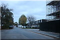
10
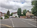
Lanacre Avenue - Burnt Oak
Road cross junction with Angus Gardens and Pageant Avenue.
Image: © James Emmans
Taken: 13 May 2020
0.21 miles