IMAGES TAKEN NEAR TO
Clayton Field, LONDON, NW9 5TH
Introduction
This page details the photographs taken nearby to Clayton Field, NW9 5TH by members of the Geograph project.
The Geograph project started in 2005 with the aim of publishing, organising and preserving representative images for every square kilometre of Great Britain, Ireland and the Isle of Man.

There are currently over 7.5m images from over14,400 individuals and you can help contribute to the project by visiting https://www.geograph.org.uk
Image Map
Images are licensed for reuse under creativecommons.org/licenses/by-sa/2.0
Notes
- Clicking on the map will re-center to the selected point.
- The higher the marker number, the further away the image location is from the centre of the postcode.
Image Listing (19 Images Found)
Images are licensed for reuse under creativecommons.org/licenses/by-sa/2.0
Image
Details
Distance
7
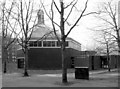
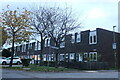
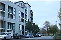
St Augustine, Great Field, Grahame Park, London NW9
Church built 1971. Architect Biscoe & Stanton.
Image: © John Salmon
Taken: 19 Feb 2008
0.16 miles
8
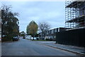
St Augustine, Great Field, Grahame Park, London NW9
Built 1971. Architect Biscoe & Stanton.
Image: © John Salmon
Taken: 19 Feb 2008
0.17 miles
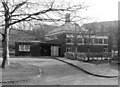
10
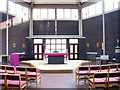
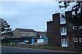
St Augustine, Great Field, Grahame Park, London NW9 - East end
Image: © John Salmon
Taken: 19 Feb 2008
0.18 miles