IMAGES TAKEN NEAR TO
Trenchard Close, LONDON, NW9 5NQ
Introduction
This page details the photographs taken nearby to Trenchard Close, NW9 5NQ by members of the Geograph project.
The Geograph project started in 2005 with the aim of publishing, organising and preserving representative images for every square kilometre of Great Britain, Ireland and the Isle of Man.

There are currently over 7.5m images from over14,400 individuals and you can help contribute to the project by visiting https://www.geograph.org.uk
Image Map
Images are licensed for reuse under creativecommons.org/licenses/by-sa/2.0
Notes
- Clicking on the map will re-center to the selected point.
- The higher the marker number, the further away the image location is from the centre of the postcode.
Image Listing (15 Images Found)
Images are licensed for reuse under creativecommons.org/licenses/by-sa/2.0
Image
Details
Distance
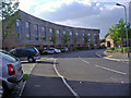
1
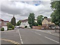
Lanacre Avenue - Burnt Oak
Road cross junction with Angus Gardens and Pageant Avenue.
Image: © James Emmans
Taken: 13 May 2020
0.04 miles
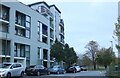
2
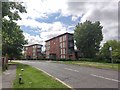
Lanacre Avenue
Modern residential flats.
Image: © James Emmans
Taken: 13 May 2020
0.05 miles
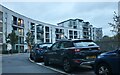
3
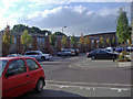
Coningsby Avenue, Grahame Park
This is part of a new development replacing some of the original council blocks on Grahame Park in the late 2000s
Image: © David Howard
Taken: 18 Sep 2008
0.15 miles
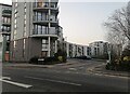
5
Kenley Avenue, Grahame Park
This is part of a new development replacing some of the original council blocks on Grahame Park in the late 2000s
Image: © David Howard
Taken: 18 Sep 2008
0.17 miles
8
Heybourne Crescent at the junction of Lanacre Avenue
Image: © David Howard
Taken: 2 Mar 2021
0.18 miles
9
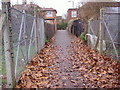
Footpath to Booth Road from Silkstream Park
Image: © David Howard
Taken: 29 Dec 2006
0.19 miles
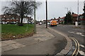
10
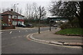
Montrose Avenue at the junction of Gervase Road
The bridge carries the Northern Line between Burnt Oak and Colindale and beyond.
Image: © David Howard
Taken: 29 Dec 2020
0.20 miles