IMAGES TAKEN NEAR TO
Lismore Boulevard, LONDON, NW9 4BY
Introduction
This page details the photographs taken nearby to Lismore Boulevard, NW9 4BY by members of the Geograph project.
The Geograph project started in 2005 with the aim of publishing, organising and preserving representative images for every square kilometre of Great Britain, Ireland and the Isle of Man.

There are currently over 7.5m images from over14,400 individuals and you can help contribute to the project by visiting https://www.geograph.org.uk
Image Map (Loading...)


Getting Data...Please wait
Leaflet Map data © OpenStreetMap
Images are licensed for reuse under creativecommons.org/licenses/by-sa/2.0
Notes
- Clicking on the map will re-center to the selected point.
- The higher the marker number, the further away the image location is from the centre of the postcode.
Image Listing (66 Images Found)
Images are licensed for reuse under creativecommons.org/licenses/by-sa/2.0
Image
Details
Distance
1
Peel Grove, Colindale
In 2019 this road is too new to be on the map.
Image: © David Howard
Taken: 21 Oct 2019
0.10 miles
2
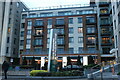
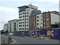
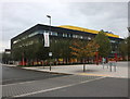
Bus at Beaufort Park
Beaufort Park is a large new housing development on a 25 acre site which was formerly part of RAF Hendon Airfield.
Image: © Des Blenkinsopp
Taken: 13 Apr 2016
0.10 miles
3
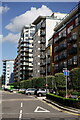
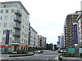
New housing in Colindale
Beaufort Park is a large development of several thousand new homes in Colindale, North West London.
Image: © Malc McDonald
Taken: 3 Jul 2011
0.11 miles
4
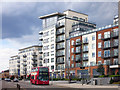
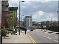
Heritage Avenue, Colindale
Heritage Avenue is a new road in the Beaufort Park development in Colindale, North West London. Several thousand new homes are being built on this development.
Image: © Malc McDonald
Taken: 3 Jul 2011
0.11 miles
6
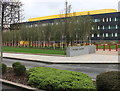
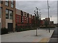
Colindale Gardens
A new development along Aerodrome Road
Image: © David Howard
Taken: 21 Oct 2019
0.11 miles
7
Former industrial site in Aerodrome Road
Areodrome Road refers to the famous Hendon Aerodrome which was best-known for its flying displays between the Wars - see https://en.wikipedia.org/wiki/Hendon_Aerodrome
Much of the south side of Aerodrome Road is taken up by the Metropolitan Police Training Establishment (known as the Peel Centre), and there are also some rather run down former industrial sites. This building seems to have once been involved in manufacturing or distributing motor parts.
The north side of Aerodrome Road had a great deal of new building of flats going on at the time this photograph was taken - see http://www.geograph.org.uk/photo/4700616
Image: © Marathon
Taken: 14 Oct 2015
0.12 miles
8
Colindale Gardens
The development goes across Peel Grove and Lismore Boulevard, and is still under construction.
Image: © David Howard
Taken: 21 Oct 2019
0.12 miles