IMAGES TAKEN NEAR TO
St. Edmunds Terrace, LONDON, NW8 7QE
Introduction
This page details the photographs taken nearby to St. Edmunds Terrace, NW8 7QE by members of the Geograph project.
The Geograph project started in 2005 with the aim of publishing, organising and preserving representative images for every square kilometre of Great Britain, Ireland and the Isle of Man.

There are currently over 7.5m images from over14,400 individuals and you can help contribute to the project by visiting https://www.geograph.org.uk
Image Map
Images are licensed for reuse under creativecommons.org/licenses/by-sa/2.0
Notes
- Clicking on the map will re-center to the selected point.
- The higher the marker number, the further away the image location is from the centre of the postcode.
Image Listing (217 Images Found)
Images are licensed for reuse under creativecommons.org/licenses/by-sa/2.0
Image
Details
Distance
2
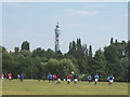
Regent's Park football, view to BT Tower
This North-West area of Regent's Park is laid out with football and other sports pitches
Image: © David Hawgood
Taken: 26 Jun 2005
0.06 miles
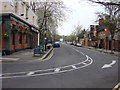
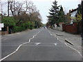
3
Roundabout near St Stephens Close
This roundabout is on a private road between Broxwood Way and Avenue Road.
Parking only for residents only.
Image: © David Anstiss
Taken: 8 Mar 2015
0.07 miles
7
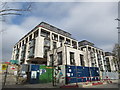
New housing development on St Edmund's Terrace
Large construction site opposite Wells Rise.
Image: © David Anstiss
Taken: 8 Mar 2015
0.10 miles
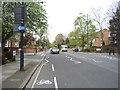
10
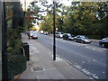
Prince Albert Road
Looking east from Avenue Road.
Image: © Colin Pyle
Taken: 18 Oct 2009
0.11 miles