IMAGES TAKEN NEAR TO
Cochrane Street, LONDON, NW8 7NX
Introduction
This page details the photographs taken nearby to Cochrane Street, NW8 7NX by members of the Geograph project.
The Geograph project started in 2005 with the aim of publishing, organising and preserving representative images for every square kilometre of Great Britain, Ireland and the Isle of Man.

There are currently over 7.5m images from over14,400 individuals and you can help contribute to the project by visiting https://www.geograph.org.uk
Image Map
Images are licensed for reuse under creativecommons.org/licenses/by-sa/2.0
Notes
- Clicking on the map will re-center to the selected point.
- The higher the marker number, the further away the image location is from the centre of the postcode.
Image Listing (531 Images Found)
Images are licensed for reuse under creativecommons.org/licenses/by-sa/2.0
Image
Details
Distance
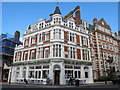
2
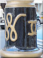
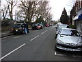
Royal cipher on a lamppost, St. John's Wood High Street, NW8
Image: © Mike Quinn
Taken: 7 Jun 2011
0.02 miles
3
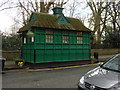
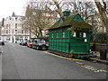
Cabmen's Shelter, Wellington Place (2)
One of Thirteen Cabmen's Shelters in London run by the Cabmen's Shelter Fund
Image: © Oxyman
Taken: 14 Apr 2008
0.04 miles
6
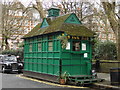
Cabmen's Shelter, Wellington Place (1)
One of Thirteen Cabmen's Shelters in London run by the Cabmen's Shelter Fund
Image: © Oxyman
Taken: 14 Apr 2008
0.04 miles
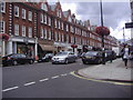
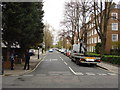
8
St John's Wood High Street / Barrow Hill Road, NW8
Image: © Mike Quinn
Taken: 7 Jun 2011
0.04 miles
9
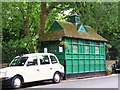
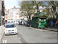
Cabmen's shelter and black cab, Wellington Place, NW8
Image: © Mike Quinn
Taken: 12 Jun 2008
0.05 miles