IMAGES TAKEN NEAR TO
St. Johns Wood Park, LONDON, NW8 6QR
Introduction
This page details the photographs taken nearby to St. Johns Wood Park, NW8 6QR by members of the Geograph project.
The Geograph project started in 2005 with the aim of publishing, organising and preserving representative images for every square kilometre of Great Britain, Ireland and the Isle of Man.

There are currently over 7.5m images from over14,400 individuals and you can help contribute to the project by visiting https://www.geograph.org.uk
Image Map
Images are licensed for reuse under creativecommons.org/licenses/by-sa/2.0
Notes
- Clicking on the map will re-center to the selected point.
- The higher the marker number, the further away the image location is from the centre of the postcode.
Image Listing (190 Images Found)
Images are licensed for reuse under creativecommons.org/licenses/by-sa/2.0
Image
Details
Distance


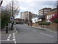
3
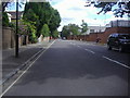
Ordnance Road
Looking south with the barracks on the right.
Image: © David Howard
Taken: 23 Jul 2009
0.04 miles
4
Queensmead Flats, St John's Wood Park, NW8
Shows the location of Image
Image: © Mike Quinn
Taken: 7 Jun 2011
0.05 miles
6
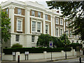
Queen's Grove, St John's Wood
This handsome block stands on the corner of Queen's Grove and Ordnance Hill.
Image: © Stephen McKay
Taken: 7 Sep 2007
0.05 miles