IMAGES TAKEN NEAR TO
St. Johns Wood Terrace, LONDON, NW8 6LR
Introduction
This page details the photographs taken nearby to St. Johns Wood Terrace, NW8 6LR by members of the Geograph project.
The Geograph project started in 2005 with the aim of publishing, organising and preserving representative images for every square kilometre of Great Britain, Ireland and the Isle of Man.

There are currently over 7.5m images from over14,400 individuals and you can help contribute to the project by visiting https://www.geograph.org.uk
Image Map
Images are licensed for reuse under creativecommons.org/licenses/by-sa/2.0
Notes
- Clicking on the map will re-center to the selected point.
- The higher the marker number, the further away the image location is from the centre of the postcode.
Image Listing (275 Images Found)
Images are licensed for reuse under creativecommons.org/licenses/by-sa/2.0
Image
Details
Distance
1
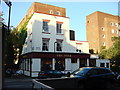
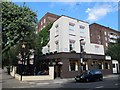
The Star
The Star Public House on the corner of Charlbert Street and Saint John's Wood Terrace
Image: © Oxyman
Taken: 22 May 2007
0.02 miles
2
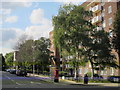
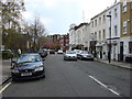
Charlbert Street / Allitsen Road, NW8
Shows the location of Image
Image: © Mike Quinn
Taken: 7 Jun 2011
0.02 miles
4
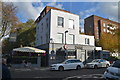
The Star (1), 38 St. John's Wood Terrace, St. John's Wood, London NW8
Located on the corner of St. John's Wood Terrace and Charlbert Street. A popular local pub, it was apparently built by Fry and Watkins in 1826, although it opened later. As late as the early 1980's there were about fourteen pubs in St. John's Wood but now there are about four. A few have been converted into cafés or restaurants.
Image
Image: © P L Chadwick
Taken: 16 Aug 2013
0.03 miles
5
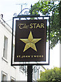
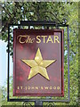
The Star (2) - sign, 38 St. John's Wood Terrace, St. John's Wood, London NW8
The sign is on a post, in gold on a dark brown background.
In days when few people could read and write, signs with easily recognised objects such as the Star were popular.
Image
Image: © P L Chadwick
Taken: 16 Aug 2013
0.03 miles
7
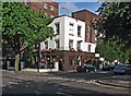
The Star, St. John's Wood Terrace / Charlbert Street, NW8
Image: © Mike Quinn
Taken: 7 Jun 2011
0.03 miles
8
Sign for The Star, St. John's Wood Terrace / Charlbert Street, NW8
See Image
Image: © Mike Quinn
Taken: 7 Jun 2011
0.04 miles
9
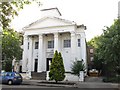
Former Congregational Chapel, St. John's Wood Terrace, NW8
The chapel was built in 1830-40; until recently it was St. John's Wood Studios. It's a Grade II listed building - see http://www.britishlistedbuildings.co.uk/en-426928-st-john-s-wood-studios-87a-marylebone.
Image: © Mike Quinn
Taken: 7 Jun 2011
0.05 miles
10
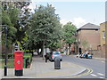
Allitsen Road, NW8
East of Charlbert Road; shows the location of Image
Image: © Mike Quinn
Taken: 7 Jun 2011
0.05 miles