IMAGES TAKEN NEAR TO
Townshend Road, LONDON, NW8 6LL
Introduction
This page details the photographs taken nearby to Townshend Road, NW8 6LL by members of the Geograph project.
The Geograph project started in 2005 with the aim of publishing, organising and preserving representative images for every square kilometre of Great Britain, Ireland and the Isle of Man.

There are currently over 7.5m images from over14,400 individuals and you can help contribute to the project by visiting https://www.geograph.org.uk
Image Map
Images are licensed for reuse under creativecommons.org/licenses/by-sa/2.0
Notes
- Clicking on the map will re-center to the selected point.
- The higher the marker number, the further away the image location is from the centre of the postcode.
Image Listing (185 Images Found)
Images are licensed for reuse under creativecommons.org/licenses/by-sa/2.0
Image
Details
Distance
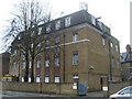
1
Primrose Hill Telephone Exchange (2)
This photo shows the TE with its mobile phone aerials on the roof and windows that jut out below, a feature of 1930s architecture. The black gateway with an old gas lamp at the entrance makes a pleasing feature.
Image: © David Hillas
Taken: 3 Apr 2012
0.00 miles
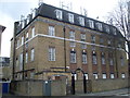
2
Primrose Hill Telephone Exchange (1)
Located at 41-43 Townshend Road NW8 6LL, this TE would appear to date from the 1930s when several large TEs were built about that time in London. It serves Primrose Hill and St John's Wood, and used to have JUNiper and PRImrose numbers until the late 1960s. Now it has 0207-483, 586 and 722 numbers, plus some Inner London numbers.
Image: © David Hillas
Taken: 3 Apr 2012
0.01 miles
4
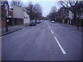
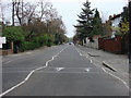
Townshend Road, St Johns Wood
One of the many straight roads in the area.
Image: © David Howard
Taken: 24 Dec 2009
0.06 miles
5
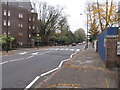
View down Avenue Road, London
If you keep going you reach Regents Park.
Image: © Richard Rogerson
Taken: 7 Nov 2011
0.07 miles
7
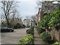
Garden path to Avenue Road
This private road and path leads from St Stephen's Close (housing block).
Image: © David Anstiss
Taken: 8 Mar 2015
0.09 miles
8
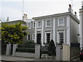
No 23 Acacia Road
A Grade II detached villa, several houses along the road are listed. Also the
Front Garden Wall and Gate Piers to Number 23 are also listed.
See http://www.britishlistedbuildings.co.uk/en-208479-23-paddington for more details about the building.
Image: © David Anstiss
Taken: 8 Mar 2015
0.09 miles
9
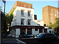
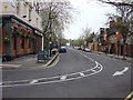
The Star
The Star Public House on the corner of Charlbert Street and Saint John's Wood Terrace
Image: © Oxyman
Taken: 22 May 2007
0.09 miles