IMAGES TAKEN NEAR TO
Queens Grove, LONDON, NW8 6EN
Introduction
This page details the photographs taken nearby to Queens Grove, NW8 6EN by members of the Geograph project.
The Geograph project started in 2005 with the aim of publishing, organising and preserving representative images for every square kilometre of Great Britain, Ireland and the Isle of Man.

There are currently over 7.5m images from over14,400 individuals and you can help contribute to the project by visiting https://www.geograph.org.uk
Image Map
Images are licensed for reuse under creativecommons.org/licenses/by-sa/2.0
Notes
- Clicking on the map will re-center to the selected point.
- The higher the marker number, the further away the image location is from the centre of the postcode.
Image Listing (192 Images Found)
Images are licensed for reuse under creativecommons.org/licenses/by-sa/2.0
Image
Details
Distance

4
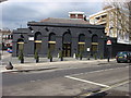
Marlborough Road tube station has turned to the dark side
Same station building as in Image but now painted black.
Image: © Oxyman
Taken: 14 Apr 2008
0.04 miles
5
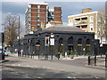
Marlborough Road tube station seen from Finchley Rd.
Image: © Oxyman
Taken: 14 Apr 2008
0.04 miles
6
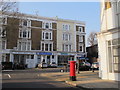
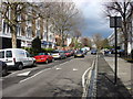
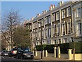
Queen's Grove / Queen's Terrace, NW8
Shows the location of Image
Image: © Mike Quinn
Taken: 8 Mar 2011
0.05 miles

8
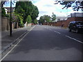
Ordnance Road
Looking south with the barracks on the right.
Image: © David Howard
Taken: 23 Jul 2009
0.06 miles
9
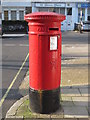
Victorian postbox, Queen's Grove / Queen's Terrace, NW8
Image: © Mike Quinn
Taken: 8 Mar 2011
0.06 miles
10
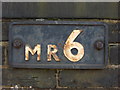
Metropolitan Railway Bridge Plate on Queen's Grove
Image: © Oxyman
Taken: 14 Apr 2008
0.06 miles