IMAGES TAKEN NEAR TO
Boundary Road, LONDON, NW8 0HU
Introduction
This page details the photographs taken nearby to Boundary Road, NW8 0HU by members of the Geograph project.
The Geograph project started in 2005 with the aim of publishing, organising and preserving representative images for every square kilometre of Great Britain, Ireland and the Isle of Man.

There are currently over 7.5m images from over14,400 individuals and you can help contribute to the project by visiting https://www.geograph.org.uk
Image Map
Images are licensed for reuse under creativecommons.org/licenses/by-sa/2.0
Notes
- Clicking on the map will re-center to the selected point.
- The higher the marker number, the further away the image location is from the centre of the postcode.
Image Listing (177 Images Found)
Images are licensed for reuse under creativecommons.org/licenses/by-sa/2.0
Image
Details
Distance
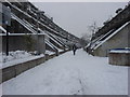
1
Path on Alexandra and Ainsworth Estate
A Camden council estate.
Image: © Robin Webster
Taken: 27 Mar 2011
0.02 miles
3
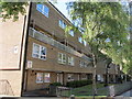
Dale House Flats, Boundary Road, NW8
Shows the location of Image
Image: © Mike Quinn
Taken: 7 Jun 2011
0.03 miles
6
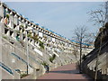
Rowley Way
The Brutalist Rowley Way, now a grade II listed building.
Image: © Oxyman
Taken: 16 Mar 2007
0.04 miles
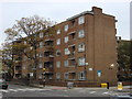
7
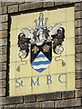
Plaque on Dale House Flats, Boundary Road, NW8
The plaque is the coat of arms of the former St. Marylebone Borough Council. The Metropolitan Borough of St Marylebone was a Metropolitan borough of the County of London from 1900 to 1965. It was that part of the current City of Westminster which is north of Oxford Street, and east of Maida Vale and Edgware Road. It included the areas Marylebone, Regent's Park, St John's Wood, and Lisson Grove, along with the western part of the district of Fitzrovia. In 1965 it was abolished and its former area was amalgamated with that of the Metropolitan Borough of Paddington and the Metropolitan Borough of Westminster to form the City of Westminster. The name is derived from a chapel, dedicated to St Mary, and founded by Barking Abbey, the holders of the Manor of Tyburn. The chapel was named St Mary-le-Bourne, for the bourne, or River Tyburn. In the borough's coat of arms, the blue and white waves represent this stream; the lily and rose, derived from Barking Abbey, represent the legend that when the Virgin's tomb was opened it was found to contain lilies and roses - see the Wiki entry http://en.wikipedia.org/wiki/Metropolitan_Borough_of_St_Marylebone. The location of this plaque is shown in Image
Image: © Mike Quinn
Taken: 7 Jun 2011
0.04 miles
8
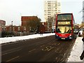
Route 189 bus on Abbey Road
The bus is approaching its Boundary Road stop and heading south.
Image: © Oxyman
Taken: 20 Dec 2010
0.06 miles