IMAGES TAKEN NEAR TO
Abbey Road, LONDON, NW8 0AE
Introduction
This page details the photographs taken nearby to Abbey Road, NW8 0AE by members of the Geograph project.
The Geograph project started in 2005 with the aim of publishing, organising and preserving representative images for every square kilometre of Great Britain, Ireland and the Isle of Man.

There are currently over 7.5m images from over14,400 individuals and you can help contribute to the project by visiting https://www.geograph.org.uk
Image Map
Images are licensed for reuse under creativecommons.org/licenses/by-sa/2.0
Notes
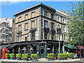
- Clicking on the map will re-center to the selected point.
- The higher the marker number, the further away the image location is from the centre of the postcode.
Image Listing (167 Images Found)
Images are licensed for reuse under creativecommons.org/licenses/by-sa/2.0
Image
Details
Distance
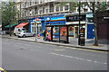
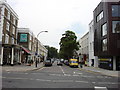
2
Shops and flats in Abbey Road, NW8
South of the junction with Boundary Road.
Image: © Mike Quinn
Taken: 7 Jun 2011
0.01 miles
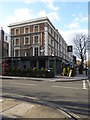
5
The Salt House, Abbey Road / Belgrave Gardens, NW8
Image: © Mike Quinn
Taken: 7 Jun 2011
0.02 miles
6

Sign for The Salt House, Abbey Road / Belgrave Gardens, NW8
See Image
Image: © Mike Quinn
Taken: 7 Jun 2011
0.02 miles
7
Boundary Road bus stop F
For Northbound buses on routes 139 and 189 on Abbey Road
Image: © Oxyman
Taken: 26 Jul 2010
0.02 miles
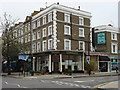
9
The Salt House
A gastropub at the junction of Abbey Road and Belgrave Gardens.
Image: © Rod Allday
Taken: 15 Feb 2016
0.02 miles
10
Boundary Road, NW8
The shops on the left are in City of Westminster and those on the right London Borough of Camden, the centre of this Road being the boundary between the two London boroughs.
Image: © Oxyman
Taken: 13 Jun 2007
0.02 miles