IMAGES TAKEN NEAR TO
Sunnyfield, LONDON, NW7 4RD
Introduction
This page details the photographs taken nearby to Sunnyfield, NW7 4RD by members of the Geograph project.
The Geograph project started in 2005 with the aim of publishing, organising and preserving representative images for every square kilometre of Great Britain, Ireland and the Isle of Man.

There are currently over 7.5m images from over14,400 individuals and you can help contribute to the project by visiting https://www.geograph.org.uk
Image Map (Loading...)


Getting Data...Please wait
Leaflet Map data © OpenStreetMap
Images are licensed for reuse under creativecommons.org/licenses/by-sa/2.0
Notes
- Clicking on the map will re-center to the selected point.
- The higher the marker number, the further away the image location is from the centre of the postcode.
Image Listing (37 Images Found)
Images are licensed for reuse under creativecommons.org/licenses/by-sa/2.0
Image
Details
Distance
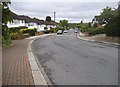
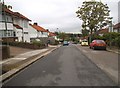
2
Sunnyfield
The northeastern side of a 'rectangular' crescent branching off to the northwest of Lawrence Street.
Image: © Martin Addison
Taken: 10 Mar 2010
0.09 miles
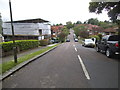
3

Entrance to allotments on Lawrence Avenue
Image: © David Howard
Taken: 28 May 2014
0.10 miles
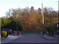
5
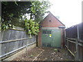
Electricity substation on Lawrence Avenue
Image: © David Howard
Taken: 28 May 2014
0.11 miles

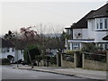
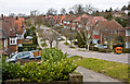
8

Footpath from Redding Close to The Redding
Image: © David Howard
Taken: 8 Feb 2011
0.14 miles