IMAGES TAKEN NEAR TO
Uphill Road, LONDON, NW7 4PU
Introduction
This page details the photographs taken nearby to Uphill Road, NW7 4PU by members of the Geograph project.
The Geograph project started in 2005 with the aim of publishing, organising and preserving representative images for every square kilometre of Great Britain, Ireland and the Isle of Man.

There are currently over 7.5m images from over14,400 individuals and you can help contribute to the project by visiting https://www.geograph.org.uk
Image Map (Loading...)


Getting Data...Please wait
Leaflet Map data © OpenStreetMap
Images are licensed for reuse under creativecommons.org/licenses/by-sa/2.0
Notes
- Clicking on the map will re-center to the selected point.
- The higher the marker number, the further away the image location is from the centre of the postcode.
Image Listing (38 Images Found)
Images are licensed for reuse under creativecommons.org/licenses/by-sa/2.0
Image
Details
Distance
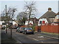
6
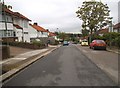
Ellesmere Avenue, NW7 (2)
Shows the location of Image Looking across the A1 (Barnet Way) towards the mock Tudor houses at the southwest end of Marsh Lane.
Image: © Mike Quinn
Taken: 14 Feb 2012
0.15 miles
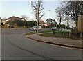
7

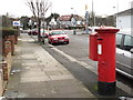
Entrance to allotments on Lawrence Avenue
Image: © David Howard
Taken: 28 May 2014
0.16 miles
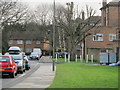
8
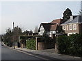
Marsh Lane, NW7 (2)
The northwest side, around Croft Close.
Image: © Mike Quinn
Taken: 14 Feb 2012
0.16 miles
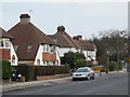
9
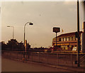
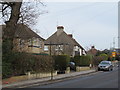
The Happy Eater on Apex Corner
I think this was taken around 1985 but may be more recent
Image: © David Howard
Taken: Unknown
0.17 miles