IMAGES TAKEN NEAR TO
Hendon Wood Lane, LONDON, NW7 4HR
Introduction
This page details the photographs taken nearby to Hendon Wood Lane, NW7 4HR by members of the Geograph project.
The Geograph project started in 2005 with the aim of publishing, organising and preserving representative images for every square kilometre of Great Britain, Ireland and the Isle of Man.

There are currently over 7.5m images from over14,400 individuals and you can help contribute to the project by visiting https://www.geograph.org.uk
Image Map
Images are licensed for reuse under creativecommons.org/licenses/by-sa/2.0
Notes
- Clicking on the map will re-center to the selected point.
- The higher the marker number, the further away the image location is from the centre of the postcode.
Image Listing (21 Images Found)
Images are licensed for reuse under creativecommons.org/licenses/by-sa/2.0
Image
Details
Distance
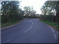
1
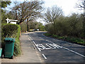
Busy Hendon Wood Lane
A short roadside stretch of the London Loop path. Loop Waymark on the lamp post.
Very busy today. I was beating the traffic at one point.
Image: © Des Blenkinsopp
Taken: 24 Oct 2013
0.06 miles
2
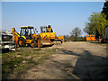
New Housing Development
Another plot of land on Hendon Wood Lane awaits development into an up-market property. Each new property is one step closer to Dollis Brook, which lies to the left of the frame. This being a Sunday, the diggers are at rest.
Image: © Martin Addison
Taken: 1 Apr 2007
0.07 miles
3

Sharp bend on Hendon Wood Lane
Taken specifically to show the stripy barrier which has been recently painted. They do show up far better like this although nowadays the exception rather than the rule.
Image: © David Howard
Taken: 12 Jan 2016
0.13 miles

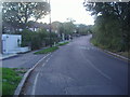
5
Corner on Hendon Wood Lane
This corner, at the bottom of a hill in each direction, is much sharper than it looks on the map and often catches drivers out. The bent armco, traffic cones and newly erected sharp bend arrows testify that someone has recently fallen into the trap. Behind the signs there is a 15 foot drop into Dollis Brook. The pavement on this part of Hendon Wood Lane forms part of the Dollis Valley Green Walk. The lane is also a popular cut through between the A411 and the A5109.
Image: © Martin Addison
Taken: 1 Apr 2007
0.13 miles
6
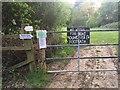
Public not welcome in Moat Mount
Image]
The owners of Mote End (or Moat End) have removed the seat overlooking the fields. They are not happy with the public walking near their fields, have blocked access to their fields with barbed wire and electric fences. The area now is restrictive and unwelcoming.
Image: © PAUL WINNETT
Taken: 8 May 2020
0.14 miles
7
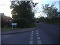
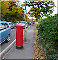
Mays Lane at the junction of Althorp Close
Image: © David Howard
Taken: 19 Oct 2011
0.17 miles
8

Footpath from Barnet Gate Lane to Hendon Wood Lane
Image: © David Howard
Taken: 19 Oct 2011
0.18 miles