IMAGES TAKEN NEAR TO
Manor Drive, LONDON, NW7 3NE
Introduction
This page details the photographs taken nearby to Manor Drive, NW7 3NE by members of the Geograph project.
The Geograph project started in 2005 with the aim of publishing, organising and preserving representative images for every square kilometre of Great Britain, Ireland and the Isle of Man.

There are currently over 7.5m images from over14,400 individuals and you can help contribute to the project by visiting https://www.geograph.org.uk
Image Map
Images are licensed for reuse under creativecommons.org/licenses/by-sa/2.0
Notes
- Clicking on the map will re-center to the selected point.
- The higher the marker number, the further away the image location is from the centre of the postcode.
Image Listing (39 Images Found)
Images are licensed for reuse under creativecommons.org/licenses/by-sa/2.0
Image
Details
Distance
1
Hale Grove Gardens and Footpath
The northwestern end of Hale Grove Gardens looking towards the continuation of the footpath from Mill Way to Manor Drive and Hale Lane. The footpath is named Lilley Lane.
Image: © Martin Addison
Taken: 10 Mar 2010
0.06 miles
8
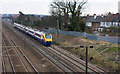
Northbound Express
A class 222 diesel unit which I believe is working a Sheffield service seen just north of Mill Hill Broadway station. The houses next to the railway are on Hale Grove Gardens.
Image: © Martin Addison
Taken: 10 Mar 2010
0.11 miles
9
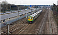
Road and Rail
View southeast from a footbridge carrying the path between Mill Way and Hale Grove Gardens. On the Left is the M1 Motorway - traffic is quite light in the middle of the day photograph. The large blue sign advises drivers of the junction with the A1 a short distance down the road - giving access to the City and Holloway as well as the A406 North Circular Road eastbound.
On the right is the St. Pancras to Leicester railway line. Approaching is a class 319 electric unit in Southern livery operating a stopping service to St. Albans City station. In the distance is Mill Hill Broadway station where the opposite direction service can be seen in the platform - in this case the destination was Brighton. On the fast lines, another train can be seen approaching Mill Hill Broadway - a fast Bedford service which calls a Luton then all stations to Bedford.
Image: © Martin Addison
Taken: 10 Mar 2010
0.11 miles