IMAGES TAKEN NEAR TO
Hollies End, LONDON, NW7 2RY
Introduction
This page details the photographs taken nearby to Hollies End, NW7 2RY by members of the Geograph project.
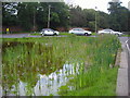
The Geograph project started in 2005 with the aim of publishing, organising and preserving representative images for every square kilometre of Great Britain, Ireland and the Isle of Man.

There are currently over 7.5m images from over14,400 individuals and you can help contribute to the project by visiting https://www.geograph.org.uk
Image Map
Images are licensed for reuse under creativecommons.org/licenses/by-sa/2.0
Notes
- Clicking on the map will re-center to the selected point.
- The higher the marker number, the further away the image location is from the centre of the postcode.
Image Listing (64 Images Found)
Images are licensed for reuse under creativecommons.org/licenses/by-sa/2.0
Image
Details
Distance
1
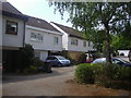
Hollies End, Mill Hill
Modern houses built in 1975, the basement of the houses is in the back below street level opening on to the gardens.
Image: © David Howard
Taken: 25 May 2010
0.01 miles
2
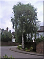
Hollies End, Mill Hill
Road and houses built in 1975
Image: © David Howard
Taken: 18 Jul 2008
0.03 miles
3
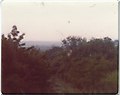
Arrandene, Mill Hill 1976
This was the view from my grandparent's top floor soon after the house was built, you could see across West London to gas holders and office blocks but some years later the trees grew to obscure the entire view.
Image: © David Howard
Taken: Unknown
0.04 miles
4
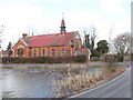
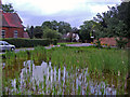
Pond and church, Mill Hill Village
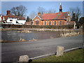
The church building is the bethel of the Brotherhood of the Cross and Star, a Christian group which originated in Nigeria in 1964. See http://bcsinternational.org/about/ for information on the beliefs and practices of the organisation. Photo taken from the south - the pond is frozen over.
Image: © David Hawgood
Taken: 5 Mar 2006
0.05 miles
5
Mill Hill Village
A view across the village pond to the Brotherhood of the Cross and Star Church.
Image: © Martin Addison
Taken: 3 Mar 2006
0.05 miles
7
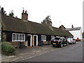
Nicoll's Almshouses, Milespit Hill, NW7
Shows the location of Image
Image: © Mike Quinn
Taken: 14 Feb 2012
0.06 miles
8
Nicholl's Almshouses, Mill Hill Village
Grade II listed almshouses, Mill Hill Village. Description at this https://historicengland.org.uk/listing/the-list/list-entry/1359092.
Image: © Jim Osley
Taken: 23 Jul 2017
0.06 miles
10
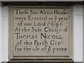
Plaque on Nicoll's Almshouses, Milespit Hill, NW7
See Image
Image: © Mike Quinn
Taken: 14 Feb 2012
0.06 miles