IMAGES TAKEN NEAR TO
Grahame Park Way, LONDON, NW7 2LA
Introduction
This page details the photographs taken nearby to Grahame Park Way, NW7 2LA by members of the Geograph project.
The Geograph project started in 2005 with the aim of publishing, organising and preserving representative images for every square kilometre of Great Britain, Ireland and the Isle of Man.

There are currently over 7.5m images from over14,400 individuals and you can help contribute to the project by visiting https://www.geograph.org.uk
Image Map
Images are licensed for reuse under creativecommons.org/licenses/by-sa/2.0
Notes
- Clicking on the map will re-center to the selected point.
- The higher the marker number, the further away the image location is from the centre of the postcode.
Image Listing (49 Images Found)
Images are licensed for reuse under creativecommons.org/licenses/by-sa/2.0
Image
Details
Distance
3
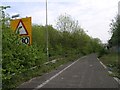
Abandoned Motorway Junction
This abandoned motorway junction appears as an off-slip of the M1 between junctions 2 and 4. It's not the missing junction 3 - that never existed. Instead, this is the original end of the M1, which was briefly re-used in the early 1990s (hence the new features) when Brent Cross was bombed by the IRA. It has an eerie post apocalyptic look with grass and vegetation growing over it.
Image: © Hywel Williams
Taken: 1 May 2005
0.09 miles
5
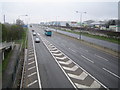
M1 Motorway: Junction 2
Viewed looking north-westwards from the footbridge over the motorway, the slip road on the left feeds in traffic from the A1 Great North Way.
Image: © Nigel Cox
Taken: 3 Apr 2007
0.14 miles
7
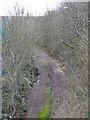
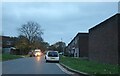
Old road - even older railway (2)
Photo taken from the A1 looking along the course of the former Mill Hill East to Edgware railway line - see Image The road (built on the line of the railway) was part of the junction at the original end of the M1 motorway where it merged with the A1. It closed in 1977 with the extension of the M1 to Staples Corner. See also Image and Image
Image: © Mike Quinn
Taken: 26 Feb 2020
0.15 miles
8
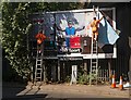
Billboard poster change-over, Bunns Lane, Mill Hill
Image: © Jim Osley
Taken: 1 Sep 2016
0.15 miles