IMAGES TAKEN NEAR TO
Oaklodge Way, LONDON, NW7 2JF
Introduction
This page details the photographs taken nearby to Oaklodge Way, NW7 2JF by members of the Geograph project.
The Geograph project started in 2005 with the aim of publishing, organising and preserving representative images for every square kilometre of Great Britain, Ireland and the Isle of Man.

There are currently over 7.5m images from over14,400 individuals and you can help contribute to the project by visiting https://www.geograph.org.uk
Image Map (Loading...)


Getting Data...Please wait
Leaflet Map data © OpenStreetMap
Images are licensed for reuse under creativecommons.org/licenses/by-sa/2.0
Notes
- Clicking on the map will re-center to the selected point.
- The higher the marker number, the further away the image location is from the centre of the postcode.
Image Listing (89 Images Found)
Images are licensed for reuse under creativecommons.org/licenses/by-sa/2.0
Image
Details
Distance
1
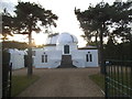
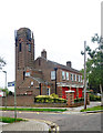
Mill Hill Observatory
Now belonging to University College London
Image: © David Howard
Taken: 11 Oct 2016
0.05 miles
2
Mill Hill Observatory
Part of University College London
Image: © David Howard
Taken: 11 Oct 2016
0.05 miles
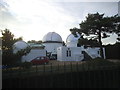
6
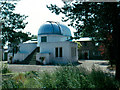
Mill Hill Observatory
University of London Observatory
Image: © John Barrett
Taken: Unknown
0.07 miles
9
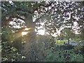
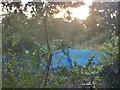
Woodlands by Watford Way, Mill Hill
You can just see the allotments on the right
Image: © David Howard
Taken: 11 Oct 2016
0.08 miles