IMAGES TAKEN NEAR TO
Pentavia Retail Park, Watford Way, LONDON, NW7 2ET
Introduction
This page details the photographs taken nearby to Pentavia Retail Park, Watford Way, NW7 2ET by members of the Geograph project.
The Geograph project started in 2005 with the aim of publishing, organising and preserving representative images for every square kilometre of Great Britain, Ireland and the Isle of Man.

There are currently over 7.5m images from over14,400 individuals and you can help contribute to the project by visiting https://www.geograph.org.uk
Image Map
Images are licensed for reuse under creativecommons.org/licenses/by-sa/2.0
Notes
- Clicking on the map will re-center to the selected point.
- The higher the marker number, the further away the image location is from the centre of the postcode.
Image Listing (40 Images Found)
Images are licensed for reuse under creativecommons.org/licenses/by-sa/2.0
Image
Details
Distance
1
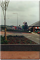
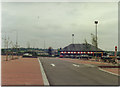
Pentavia Retail Park, Mill Hill
Pentavia is Latin for five ways, as it's next to Fiveways Corner
Image: © David Howard
Taken: Unknown
0.07 miles
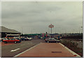
2
M1 motorway at junction 2
The curious structure on the right is associated with a Nissan facility.
Image: © Peter Whatley
Taken: 3 Apr 2012
0.08 miles
3
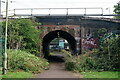
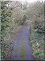
Mill Hill
Footpath under the railway line.
Image: © Peter Trimming
Taken: 3 Oct 2021
0.08 miles
4
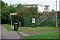
Mill Hill
Footpath under the railway line.
Image: © Peter Trimming
Taken: 3 Oct 2021
0.09 miles
7

London Borough of Barnet : Charmille Avenue
Looking towards some new flats on Charmille Avenue.
Image: © Lewis Clarke
Taken: 4 Oct 2018
0.09 miles
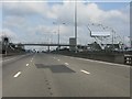
8
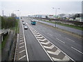
M1 Motorway: Junction 2
Viewed looking north-westwards from the footbridge over the motorway, the slip road on the left feeds in traffic from the A1 Great North Way.
Image: © Nigel Cox
Taken: 3 Apr 2007
0.10 miles
9
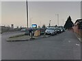
Watford Way at the corner of Tithe Walk
Image: © David Howard
Taken: 2 Mar 2021
0.10 miles
10
Old road - even older railway
Photo taken from the A1 looking along the course of the former Mill Hill East to Edgware railway line - see Image The railway would have carried straight on where the road starts to curve to the right. The road was part of the junction at the original end of the M1 motorway where it merged with the A1. It closed in 1977 with the extension of the M1 to Staples Corner. See also Image and Image
Image: © Mike Quinn
Taken: 26 Feb 2020
0.11 miles