IMAGES TAKEN NEAR TO
Rowlands Close, LONDON, NW7 2DW
Introduction
This page details the photographs taken nearby to Rowlands Close, NW7 2DW by members of the Geograph project.
The Geograph project started in 2005 with the aim of publishing, organising and preserving representative images for every square kilometre of Great Britain, Ireland and the Isle of Man.

There are currently over 7.5m images from over14,400 individuals and you can help contribute to the project by visiting https://www.geograph.org.uk
Image Map (Loading...)


Getting Data...Please wait
Leaflet Map data © OpenStreetMap
Images are licensed for reuse under creativecommons.org/licenses/by-sa/2.0
Notes
- Clicking on the map will re-center to the selected point.
- The higher the marker number, the further away the image location is from the centre of the postcode.
Image Listing (51 Images Found)
Images are licensed for reuse under creativecommons.org/licenses/by-sa/2.0
Image
Details
Distance
2
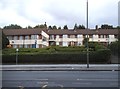
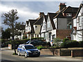
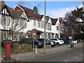
Bunn's Lane, NW7 (3)
The north side, west of its junction with Rowlands Close.
Image: © Mike Quinn
Taken: 26 Feb 2020
0.04 miles
4
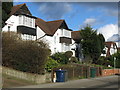
Suburban housing, Bunn's Lane, Mill Hill
Image: © Christopher Hilton
Taken: 19 Apr 2017
0.05 miles
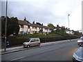
5
Bunn's Lane, NW7 (2)
The north side, west of Copthall Drive.
Image: © Mike Quinn
Taken: 26 Feb 2020
0.05 miles
6
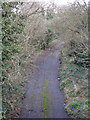
Old road - even older railway
Photo taken from the A1 looking along the course of the former Mill Hill East to Edgware railway line - see Image The railway would have carried straight on where the road starts to curve to the right. The road was part of the junction at the original end of the M1 motorway where it merged with the A1. It closed in 1977 with the extension of the M1 to Staples Corner. See also Image and Image
Image: © Mike Quinn
Taken: 26 Feb 2020
0.08 miles
7
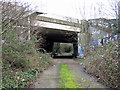
A1 bridge over old road
The old road is also the course of the former Mill Hill East to Edgware railway line. See also Image and Image
Image: © Mike Quinn
Taken: 26 Feb 2020
0.09 miles
8
Former M1 slip-road at Bunn's Lane
Before the current south end of the M1 was completed, a temporary junction 2 (just north of the current one at Fiveways Corner) ushered traffic onto and off the A1 Watford Way. This slip road enabled southbound traffic to pass under the A1 Watford Way and merge into that road's southbound carriageway. For more details see http://www.sabre-roads.org.uk/wiki/index.php?title=Fiveways_Interchange. For what would have been the driver's view approaching this bridge from the north-west, see Image
The slip road follows the line of the abandoned Mill Hill East to Edgware railway: had it not been for changing priorities (due in part to the Second World War, and the Green Belt slowing suburban expansion) this would have formed part of the Northern Line. Under London Transport's Northern Heights Scheme, part of the 1930s New Works Programme, the Northern Line would have taken over various LNER branch lines to form an extensive and complicated network: the line from Highgate to High Barnet and its spur to Mill Hill East is all that remains of this ambitious programme.
Image: © Christopher Hilton
Taken: 19 Apr 2017
0.10 miles
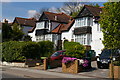
9
Bunn's Lane, NW7
The north side, just beyond its junction with Copthall Drive.
Image: © Mike Quinn
Taken: 26 Feb 2020
0.10 miles
10
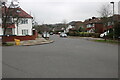
Copthall Drive at the junction of Hillside Grove
Image: © David Howard
Taken: 29 Dec 2020
0.11 miles