IMAGES TAKEN NEAR TO
Featherstone Road, LONDON, NW7 2BL
Introduction
This page details the photographs taken nearby to Featherstone Road, NW7 2BL by members of the Geograph project.
The Geograph project started in 2005 with the aim of publishing, organising and preserving representative images for every square kilometre of Great Britain, Ireland and the Isle of Man.

There are currently over 7.5m images from over14,400 individuals and you can help contribute to the project by visiting https://www.geograph.org.uk
Image Map
Images are licensed for reuse under creativecommons.org/licenses/by-sa/2.0
Notes
- Clicking on the map will re-center to the selected point.
- The higher the marker number, the further away the image location is from the centre of the postcode.
Image Listing (44 Images Found)
Images are licensed for reuse under creativecommons.org/licenses/by-sa/2.0
Image
Details
Distance
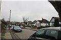
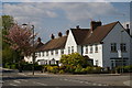
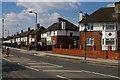
4
Pursley Road
A mix of terrace and semi-detached housing by the junction with Featherstone Road. The red 30MPH LED sign might as well be permanently on - nearly every approaching car made it light up.
Image: © Martin Addison
Taken: 19 Jan 2009
0.07 miles
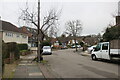
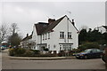
5
Housing on Pursley Road, Mill Hill
Image: © Christopher Hilton
Taken: 19 Apr 2017
0.08 miles
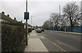
6
Featherstone Road at the junction of Bunns Lane
Image: © David Howard
Taken: 29 Dec 2020
0.09 miles
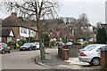
8
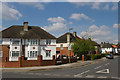
Housing on Brookfield Avenue, Mill Hill
Image: © Christopher Hilton
Taken: 19 Apr 2017
0.14 miles
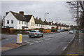
9
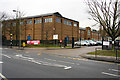
Copthall School
A comprehensive school and 6th form college on Pursley Road.
Image: © Martin Addison
Taken: 19 Jan 2009
0.14 miles
10
Housing on Pursley Road, Mill Hill
Image: © Christopher Hilton
Taken: 19 Apr 2017
0.14 miles