IMAGES TAKEN NEAR TO
Grenfell Court, Wise Lane, LONDON, NW7 2BJ
Introduction
This page details the photographs taken nearby to Grenfell Court, Wise Lane, NW7 2BJ by members of the Geograph project.
The Geograph project started in 2005 with the aim of publishing, organising and preserving representative images for every square kilometre of Great Britain, Ireland and the Isle of Man.

There are currently over 7.5m images from over14,400 individuals and you can help contribute to the project by visiting https://www.geograph.org.uk
Image Map (Loading...)


Getting Data...Please wait
Leaflet Map data © OpenStreetMap
Images are licensed for reuse under creativecommons.org/licenses/by-sa/2.0
Notes
- Clicking on the map will re-center to the selected point.
- The higher the marker number, the further away the image location is from the centre of the postcode.
Image Listing (30 Images Found)
Images are licensed for reuse under creativecommons.org/licenses/by-sa/2.0
Image
Details
Distance
4
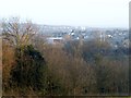
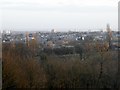
View from Mill Hill School grounds
Looking SE across Mill Hill and beyond
Image: © David Howard
Taken: 26 Feb 2014
0.13 miles
5
View from Mill Hill School grounds
Looking south across Mill Hill and beyond
Image: © David Howard
Taken: 26 Feb 2014
0.13 miles
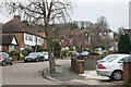
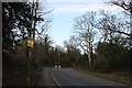
6
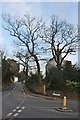
Wise Lane at the corner of Page Street
Image: © David Howard
Taken: 12 Feb 2020
0.14 miles
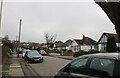
7
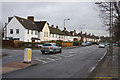
Pursley Road
A mix of terrace and semi-detached housing by the junction with Featherstone Road. The red 30MPH LED sign might as well be permanently on - nearly every approaching car made it light up.
Image: © Martin Addison
Taken: 19 Jan 2009
0.15 miles
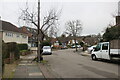
8
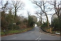
Wise Lane at the corner of Page Street
Arrandene is on the left
Image: © David Howard
Taken: 12 Feb 2020
0.15 miles
9
Page Street at the junction of Wise Lane
Image: © David Howard
Taken: 12 Feb 2020
0.15 miles
10
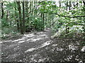
Woodland on the southern slope of Featherstone hill
Featherstone Hill is part of the stretch of old countryside on the southern slopes of Mill Hill known as Arrandene Open Space. Although it is surrounded by houses on three sides, it has retained a rural quality. To the north are small fields, divided by tall hedgerows and small pockets of woodland which are reminiscent of many Hertfordshire and Middlesex farms before the building boom of the 1930s. The grasslands were once used for producing hay for sale in London at a time when there was a large population of working horses.
Most of the site was purchased by the local authority in 1929. The landscape is undulating, with its highest points at Featherstone Hill in the west and Mill Hill Ridge in the north-east. There are fine views west across the valley of the Silk Stream towards Harrow-on-the-Hill and Stanmore Common, although the growth of surrounding trees has cut the view from Featherstone Hill in other directions. The field at Featherstone Hill was actually a cornfield before the Second World War and until the late 1940s.
Towards the south-west of the site, the grass was left unmanaged for many years and as a result woodland has grown up, to engulf many of the oak, ash and crack-willow trees as seen here.
Image: © Marathon
Taken: 5 Oct 2016
0.15 miles