1
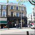
Kilburn High Road, NW6
At the junction of Cavendish Road and Iverson Road. Brondesbury Station is ahead.
Image: © Danny P Robinson
Taken: 18 Mar 2007
0.02 miles
2
Kilburn: A5 Shoot Up Hill
Looking up the former Roman Road of Watling Street the pale blue bridge carries Network Rail's Chiltern Line tracks over Shoot Up Hill. To record ever volatile fuel prices at a moment in time the Total garage on the left is selling unleaded petrol at 96.9 pence and diesel at 97.9 pence per litre.
Image: © Nigel Cox
Taken: 19 Aug 2007
0.02 miles
3
North London Tavern, Kilburn, London NW6
Formerly a hotel, the pub is at 375 Kilburn High Road on the corner of Cavendish Road.
Image: © Jaggery
Taken: 12 May 2012
0.02 miles
4
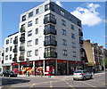
Sainsbury's Local under a block of flats, Kilburn
On the corner of Kilburn High Road and Cavendish Road, opposite the North London Tavern. http://www.geograph.org.uk/photo/2969747
Image: © Jaggery
Taken: 12 May 2012
0.02 miles
5
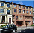
Brondesbury Christian Church, London Nw6
Located on the north side of Iverson Road, about 70 metres east of Kilburn High Road (the A5).
Image: © Jaggery
Taken: 12 May 2012
0.02 miles
6
Kilburn High Road at the junction of Cavendish Road
Image: © David Howard
Taken: 14 Mar 2015
0.02 miles
7
Brondesbury Station
View NE, towards Dalston Junction and Broad Street; ex-North London Rly. Broad Street - Dalston Junction - Willesden Junction - Richmond line: both an electrified suburban line and a major route for cross-London freight. (In the distance can be seen the overbridge carrying the Metropolitan and LNER (ex-Great Central) six lines into Baker Street and Marylebone).
Image: © Ben Brooksbank
Taken: 19 Feb 1961
0.03 miles
8
Brondesbury railway station, Greater London
Opened in 1860 as 'Edgeware Road (Kilburn)' by the Hampstead Junction Railway on the line from Dalston to Willesden, this station was renamed several times before becoming Brondesbury in 1883.
View north east towards West Hampstead and Dalston. See
Image] for 1961 image from a similar viewpoint.
Image: © Nigel Thompson
Taken: 2 Apr 2013
0.03 miles
9
Brondesbury Station
Opened as Edgeware (sic) Road and Kilburn on 2 January 1860 and re-named as Brondesbury in 1883, this is another station whose fortunes have been dramatically revived since becoming part of the Overground. This view, looking east, shows there is room for more improvement from the point of view of passenger comfort.
Image: © Dr Neil Clifton
Taken: 25 Nov 2015
0.03 miles
10
Sainsbury's Local on Kilburn High Road
Image: © David Howard
Taken: 14 Mar 2015
0.03 miles


