IMAGES TAKEN NEAR TO
Willesden Lane, LONDON, NW6 7SY
Introduction
This page details the photographs taken nearby to Willesden Lane, NW6 7SY by members of the Geograph project.
The Geograph project started in 2005 with the aim of publishing, organising and preserving representative images for every square kilometre of Great Britain, Ireland and the Isle of Man.

There are currently over 7.5m images from over14,400 individuals and you can help contribute to the project by visiting https://www.geograph.org.uk
Image Map
Images are licensed for reuse under creativecommons.org/licenses/by-sa/2.0
Notes
- Clicking on the map will re-center to the selected point.
- The higher the marker number, the further away the image location is from the centre of the postcode.
Image Listing (194 Images Found)
Images are licensed for reuse under creativecommons.org/licenses/by-sa/2.0
Image
Details
Distance
3
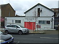
Kilburn Evangelical Free Church
On Aldershot Road.
Image: © JThomas
Taken: 18 Mar 2017
0.04 miles
4
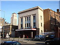
Cinema 3rd class entrance
This was the 3rd class entrance to the Gaumont State Cinema
Image: © Oxyman
Taken: 11 Mar 2007
0.05 miles
5
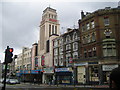
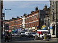
Kilburn: The former Gaumont State Cinema
The Gaumont State Cinema opened in December 1937 and was the largest single auditorium cinema ever built in England with a seating capacity of 4,004. 2,648 of these were in the stalls and 1,356 on the balcony. Over the years changes in the demands of the public meant that gradually more and more space was taken over for bingo, until eventually in 1990 the building's use as a cinema ceased entirely, and it became a bingo hall only.
However in recent years the bingo venture itself had been losing money and the owners of the building, the Rank Group plc, decided to cease operations. The building appeared in a run-down state when photographed on 19 August 2007, with the faulty neon sign symptomatic of its state. Unbeknownst to the photographer this was in fact its last day of operation, having just failed to reach its 70th birthday of entertaining the public.
The cinema was designed by the architect George Coles and the 120 feet high tower was meant to resemble the Empire State Building in New York. The building was Grade II listed in 1980, but its future is uncertain.
The road is the A5 Kilburn High Road, which is the former Roman road of Watling Street.
Image: © Nigel Cox
Taken: 19 Aug 2007
0.05 miles
6
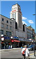
Ruach Ministries, Kilburn (formerly Gaumont State Cinema)
The building with a 120 ft tower on Kilburn High Road was opened
in December 1937 as the Gaumont State Cinema. See http://www.geograph.org.uk/photo/569442
for a potted history of the building. In December 2007, the building
was bought by Ruach City Church, a non-denominational Christian church.
Image: © Jaggery
Taken: 12 May 2012
0.05 miles