IMAGES TAKEN NEAR TO
Brondesbury Park, LONDON, NW6 7BR
Introduction
This page details the photographs taken nearby to Brondesbury Park, NW6 7BR by members of the Geograph project.
The Geograph project started in 2005 with the aim of publishing, organising and preserving representative images for every square kilometre of Great Britain, Ireland and the Isle of Man.

There are currently over 7.5m images from over14,400 individuals and you can help contribute to the project by visiting https://www.geograph.org.uk
Image Map
Images are licensed for reuse under creativecommons.org/licenses/by-sa/2.0
Notes
- Clicking on the map will re-center to the selected point.
- The higher the marker number, the further away the image location is from the centre of the postcode.
Image Listing (83 Images Found)
Images are licensed for reuse under creativecommons.org/licenses/by-sa/2.0
Image
Details
Distance
1
Brondesbury Park, NW6 (2)
Shows the location of Image
Image: © Mike Quinn
Taken: 4 Jul 2011
0.04 miles
2
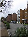
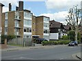
Low-rise apartment blocks, Brondesbury Road
Image: © David Smith
Taken: 26 Nov 2015
0.05 miles
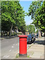
3

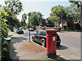
Victorian postbox, Brondesbury Park, NW6 - royal cipher
See Image
Image: © Mike Quinn
Taken: 4 Jul 2011
0.05 miles
4
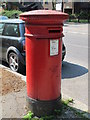
Victorian postbox, Brondesbury Park, NW6
Image: © Mike Quinn
Taken: 4 Jul 2011
0.05 miles
5
Brondesbury Park, NW6 (3)
Shows the location of Image
Image: © Mike Quinn
Taken: 4 Jul 2011
0.05 miles
7
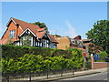
Brondesbury Park, NW6
North of its junction with Christchurch Avenue.
Image: © Mike Quinn
Taken: 4 Jul 2011
0.06 miles
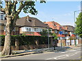
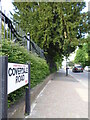
9

Houses in Brondesbury Park, at the corner of Coverdale Road
Image: © David Smith
Taken: 26 Nov 2015
0.07 miles