IMAGES TAKEN NEAR TO
Lonsdale Road, LONDON, NW6 6RA
Introduction
This page details the photographs taken nearby to Lonsdale Road, NW6 6RA by members of the Geograph project.
The Geograph project started in 2005 with the aim of publishing, organising and preserving representative images for every square kilometre of Great Britain, Ireland and the Isle of Man.

There are currently over 7.5m images from over14,400 individuals and you can help contribute to the project by visiting https://www.geograph.org.uk
Image Map
Images are licensed for reuse under creativecommons.org/licenses/by-sa/2.0
Notes
- Clicking on the map will re-center to the selected point.
- The higher the marker number, the further away the image location is from the centre of the postcode.
Image Listing (126 Images Found)
Images are licensed for reuse under creativecommons.org/licenses/by-sa/2.0
Image
Details
Distance
1
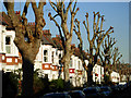
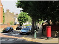
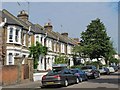
Hartland Road, Kilburn
The pollarded trees lining this suburban street off Salusbury Road make a dramatic outline against the blue winter sky.
Image: © Stephen McKay
Taken: 6 Jan 2009
0.07 miles
2
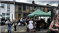
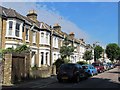
Queen's Park Farmers' Market, Lonsdale Road
Image: © Bryn Holmes
Taken: 17 Sep 2023
0.08 miles
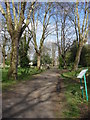
10
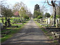
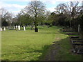
Paddington Cemetery
Looking northwards towards the chapel
Image: © Oxyman
Taken: 15 Apr 2008
0.11 miles