IMAGES TAKEN NEAR TO
Milman Road, LONDON, NW6 6EN
Introduction
This page details the photographs taken nearby to Milman Road, NW6 6EN by members of the Geograph project.
The Geograph project started in 2005 with the aim of publishing, organising and preserving representative images for every square kilometre of Great Britain, Ireland and the Isle of Man.

There are currently over 7.5m images from over14,400 individuals and you can help contribute to the project by visiting https://www.geograph.org.uk
Image Map
Images are licensed for reuse under creativecommons.org/licenses/by-sa/2.0
Notes
- Clicking on the map will re-center to the selected point.
- The higher the marker number, the further away the image location is from the centre of the postcode.
Image Listing (108 Images Found)
Images are licensed for reuse under creativecommons.org/licenses/by-sa/2.0
Image
Details
Distance
1
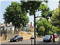
Harvist Road, NW6 (2)
Shows the location of Image
Image: © Mike Quinn
Taken: 4 Jul 2011
0.04 miles
5
Harvist Road, NW6 (3)
Shows the location of Image
Image: © Mike Quinn
Taken: 4 Jul 2011
0.05 miles
6
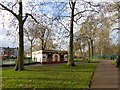
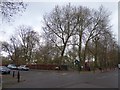
Toilet block and play area, Queen's Park
Image: © David Smith
Taken: 26 Nov 2015
0.05 miles
7
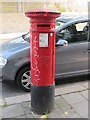
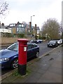
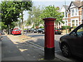
Victorian postbox, Harvist Road, NW6
Just west of the southern end of Milman Road. The location of this postbox is shown in Image, Image and Image
Image: © Mike Quinn
Taken: 4 Jul 2011
0.05 miles
8
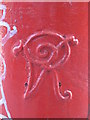
Victorian postbox, Harvist Road, NW6 - royal cipher
See Image
Image: © Mike Quinn
Taken: 4 Jul 2011
0.05 miles
9
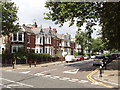
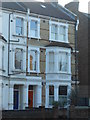
Milman Road, Kensal Rise
These houses are opposite Queen's Park
Image: © David Hawgood
Taken: 15 Aug 2005
0.05 miles
10
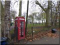
Telephone box set into the railings of Queens Park
Image: © David Smith
Taken: 26 Nov 2015
0.05 miles