IMAGES TAKEN NEAR TO
Gorefield Place, LONDON, NW6 5SX
Introduction
This page details the photographs taken nearby to Gorefield Place, NW6 5SX by members of the Geograph project.
The Geograph project started in 2005 with the aim of publishing, organising and preserving representative images for every square kilometre of Great Britain, Ireland and the Isle of Man.

There are currently over 7.5m images from over14,400 individuals and you can help contribute to the project by visiting https://www.geograph.org.uk
Image Map
Images are licensed for reuse under creativecommons.org/licenses/by-sa/2.0
Notes
- Clicking on the map will re-center to the selected point.
- The higher the marker number, the further away the image location is from the centre of the postcode.
Image Listing (225 Images Found)
Images are licensed for reuse under creativecommons.org/licenses/by-sa/2.0
Image
Details
Distance
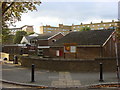
6

New flats on Kilburn Park Road
These have recently been completed.
Image: © David Howard
Taken: 20 Jan 2022
0.10 miles
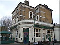
7
The Prince of Wales and the Station
The Prince of Wales pub next to the ornate maroon tiling of Kilburn Park Underground Station.
Image: © Des Blenkinsopp
Taken: 8 Jun 2016
0.10 miles