IMAGES TAKEN NEAR TO
Heritage Lane, LONDON, NW6 2BR
Introduction
This page details the photographs taken nearby to Heritage Lane, NW6 2BR by members of the Geograph project.
The Geograph project started in 2005 with the aim of publishing, organising and preserving representative images for every square kilometre of Great Britain, Ireland and the Isle of Man.

There are currently over 7.5m images from over14,400 individuals and you can help contribute to the project by visiting https://www.geograph.org.uk
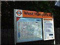
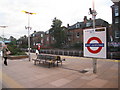
Image Map
Images are licensed for reuse under creativecommons.org/licenses/by-sa/2.0
Notes
- Clicking on the map will re-center to the selected point.
- The higher the marker number, the further away the image location is from the centre of the postcode.
Image Listing (347 Images Found)
Images are licensed for reuse under creativecommons.org/licenses/by-sa/2.0
Image
Details
Distance
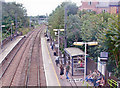
1
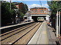
West Hampstead station (NLL), NW6
We're not supposed to call it the North London Line (NLL) anymore, it's just another station part of the London Overground network.
The middle of three stations all confusingly called guess what?
All within 200 yards of each other, in Kilburn, it's more posh to refer it as West Hampstead instead.
Image: © Phillip Perry
Taken: 21 Sep 2009
0.01 miles
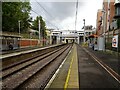
2
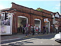
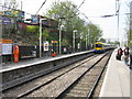
West Hampstead railway station
Looking a lot more inviting then in Image West Hampstead railway station has since had a refurbishment and is now being run by London Overground. The ticket office has a new layout including automatic ticket gates and machines and is now staffed throughout traffic hours (as are all London Overground stations).
Image: © Oxyman
Taken: 4 Jul 2008
0.02 miles
3
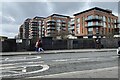
Flats, West Hampstead
Flats on Heritage Lane overlook the railway west of West Hampstead Underground station (Metropolitan and Jubilee Lines and the adjacent Chiltern Railways main line). The view is across West End Lane from near the station entrance.
Image: © Robin Stott
Taken: 7 Mar 2023
0.02 miles
4
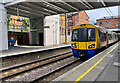
West Hampstead Station
The overground station, one of three (Thameslink, Overground and Jubilee Line) separate but adjacent rail stations in the area. The train here is heading west towards Richmond.
Image: © Paul Harrop
Taken: 4 Sep 2021
0.02 miles
7
West Hampstead (North London line) station
The station was in the process of receiving "London Overground" branding. A train has just left en route to Richmond.
Image: © Peter Whatley
Taken: 11 Apr 2011
0.02 miles
8
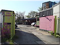
Pink Car Wash
Popular with owners of Porshes and stretched limos
Image: © Oxyman
Taken: 18 Apr 2009
0.02 miles
9
West Hampstead Station, North London Line, 2007
'West End Lane' until May 1975, the view is westward, towards Willesden Junction and Richmond/Clapham Junction: ex-LNWR (North London Railway) Richmond - Willesden Junction - Camden Road - Dalston Junction - Broad Street line, electrified (DC, third-rail) from 1916, diverted 1985 from Broad Street to terminate at North Woolwich, later Stratford, being operated by DMUs from 1979, then converted to 25kV overhead electric supply by May 2010. After privatisation, the passenger service was provided by Silverlink, then by London Overground since 2007. [I am not certain of the situation when I took this photograph in July 2007] [?]
Image: © Ben Brooksbank
Taken: 28 Jul 2007
0.02 miles
10
West Hampstead (North London Line) railway station
Opened in 1888 as West End Lane by the Hampstead Junction Railway on the line from Dalston to Willesden, this station only changed its name to West Hampstead in 1975.
View east towards Finchley Road & Frognall and Dalston, shortly after it had been substantially built. Compared with Image, the platform is wider and a new footbridge and station building have been erected. The 1888 station building was still extant but no longer connected directly to the platforms.
Image: © Nigel Thompson
Taken: 15 Oct 2020
0.02 miles