IMAGES TAKEN NEAR TO
West End Lane, LONDON, NW6 2AA
Introduction
This page details the photographs taken nearby to West End Lane, NW6 2AA by members of the Geograph project.
The Geograph project started in 2005 with the aim of publishing, organising and preserving representative images for every square kilometre of Great Britain, Ireland and the Isle of Man.

There are currently over 7.5m images from over14,400 individuals and you can help contribute to the project by visiting https://www.geograph.org.uk
Image Map
Images are licensed for reuse under creativecommons.org/licenses/by-sa/2.0
Notes
- Clicking on the map will re-center to the selected point.
- The higher the marker number, the further away the image location is from the centre of the postcode.
Image Listing (276 Images Found)
Images are licensed for reuse under creativecommons.org/licenses/by-sa/2.0
Image
Details
Distance
1
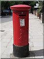
Edward VII postbox, West End Lane / Hemstal Road, NW6
Image: © Mike Quinn
Taken: 8 Jun 2011
0.02 miles
2
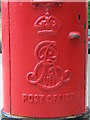
Edward VII postbox, West End Lane / Hemstal Road, NW6 - royal cipher
See Image
Image: © Mike Quinn
Taken: 8 Jun 2011
0.02 miles

4
West End Lane / Hemstal Road, NW6
Shows the location of Image
Image: © Mike Quinn
Taken: 8 Jun 2011
0.03 miles
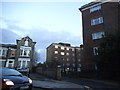
8
House on West End Lane, West Hampstead
The white house is the Acol Bridge Centre, originally down the road in Acol Road.
Image: © David Howard
Taken: 19 Jan 2017
0.05 miles
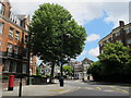
9
Houses, West End Lane
At the junction of Hemstal Road
Image: © Robin Sones
Taken: 17 Oct 2018
0.05 miles
10
Compayne Gardens, West Hampstead
From West End Lane
Image: © David Howard
Taken: 19 Feb 2014
0.05 miles