IMAGES TAKEN NEAR TO
Solent Road, LONDON, NW6 1TP
Introduction
This page details the photographs taken nearby to Solent Road, NW6 1TP by members of the Geograph project.
The Geograph project started in 2005 with the aim of publishing, organising and preserving representative images for every square kilometre of Great Britain, Ireland and the Isle of Man.

There are currently over 7.5m images from over14,400 individuals and you can help contribute to the project by visiting https://www.geograph.org.uk
Image Map
Images are licensed for reuse under creativecommons.org/licenses/by-sa/2.0
Notes
- Clicking on the map will re-center to the selected point.
- The higher the marker number, the further away the image location is from the centre of the postcode.
Image Listing (213 Images Found)
Images are licensed for reuse under creativecommons.org/licenses/by-sa/2.0
Image
Details
Distance
1
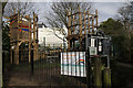
Sumatra Road Play Area
A small section of Sumatra Road Open Space fenced off to provide an adventure playground for small children.
Image: © Martin Addison
Taken: 11 Mar 2011
0.02 miles
2
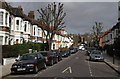
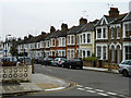
Sumatra Road
Looking up the hill towards Mill Lane. The housing here dates to around the 1880's. The pollarded trees would appear to Limes.
Image: © Martin Addison
Taken: 11 Mar 2011
0.04 miles
5
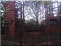
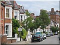
Sumatra Road
A quiet residential area.
Image: © Robin Webster
Taken: 29 Jan 2011
0.05 miles
6
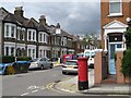
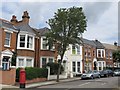
Sumatra Road / Pandora Road, NW6
Shows the location of Image
Image: © Mike Quinn
Taken: 8 Jun 2011
0.05 miles
7
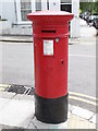
Victorian postbox, Sumatra Road / Pandora Road, NW6
Image: © Mike Quinn
Taken: 8 Jun 2011
0.06 miles
8

Victorian postbox, Sumatra Road / Pandora Road, NW6 - royal cipher
See Image
Image: © Mike Quinn
Taken: 8 Jun 2011
0.06 miles
10
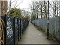
Black Path
From the end of Broomsleigh Street, just behind the camera, to West End Lane, running beside the railway.
Image: © Robin Webster
Taken: 29 Jan 2011
0.07 miles