IMAGES TAKEN NEAR TO
Mill Lane, LONDON, NW6 1NT
Introduction
This page details the photographs taken nearby to Mill Lane, NW6 1NT by members of the Geograph project.
The Geograph project started in 2005 with the aim of publishing, organising and preserving representative images for every square kilometre of Great Britain, Ireland and the Isle of Man.

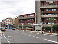
There are currently over 7.5m images from over14,400 individuals and you can help contribute to the project by visiting https://www.geograph.org.uk
Image Map
Images are licensed for reuse under creativecommons.org/licenses/by-sa/2.0
Notes
- Clicking on the map will re-center to the selected point.
- The higher the marker number, the further away the image location is from the centre of the postcode.
Image Listing (102 Images Found)
Images are licensed for reuse under creativecommons.org/licenses/by-sa/2.0
Image
Details
Distance
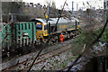
1
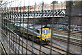
Mill Lane Bridge and The Railway
Seen through the grill of the fence of Wayne Kirkum Way - see Image and Image The bridge is quite a massive structure and you get no impression of the girder work below as you walk over it. In the foreground are the freight lines as evidenced by the recycling train behind a class 66 diesel. The next pair are the fast lines and the furthest tracks are the slow lines, on which a local service can just be seen.
Image: © Martin Addison
Taken: 11 Mar 2011
0.03 miles
2
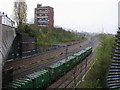
Mill Lane Railway Lines
Below the Mill Lane bridge railway lines heading to West Hampstead
Image: © Shaun Ferguson
Taken: 24 Apr 2008
0.03 miles
3
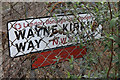
Wayne Kirkum Way
The street sign for this footpath that connects Mill Lane with Brassey Road on the West End Sidings Estate. Beneath, a small plaque recalls the death of teenager Wayne Kirkum who was killed on the railway in June 1984.
Image: © Martin Addison
Taken: 11 Mar 2011
0.04 miles
4
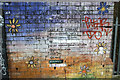
Mill Lane Bridge Mural
The steel panels of Mill Lane Bridge were painted in August 2000 as commemorated by this mural on the brickwork at the eastern end of the bridge.
Image: © Martin Addison
Taken: 11 Mar 2011
0.04 miles
5
Mill Lane, West Hampstead
This is at the Western edge of the borough of Camden, who own the block of flats "Ellerton" in the photo.
Image: © David Hawgood
Taken: 20 Aug 2005
0.04 miles
6
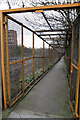
Wayne Kirkum Way
This enclosed footpath descends alongside the railway in a series of loops to the West End Sidings estate, connecting Mill Lane with Brassey Road. It is named after a teenager who was killed on the railway in June 1984.
Image: © Martin Addison
Taken: 11 Mar 2011
0.05 miles
7
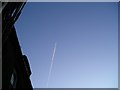
Sky Marks
Fascinating lines in the sky left by passing planes. Taken on one Sunday afternoon whilst relaxing in my garden.
Image: © Trionon
Taken: 15 Jan 2012
0.05 miles
8
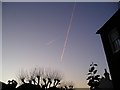
Sky Marks
Fascinating lines in the sky left by passing planes. Taken on one Sunday afternoon whilst relaxing in my garden.
Image: © Trionon
Taken: 15 Jan 2012
0.05 miles
9
Ready to Run Round
66558 stands waiting to be uncoupled from her train between Cricklewood and West Hampstead. The service comes from the North London Waste Authority's Hendon transfer station. From here the train, containing waste, will head north to Stewartby. The service removes 192 long-distance lorries from the roads each day according to the Freight On Rail website.
In the distance the tracks curve to pass through West Hampstead Station, under West End Lane and into the tunnels under Hampstead. This shot was taken through the fence of Wayne Kirkum Way.
Image: © Martin Addison
Taken: 11 Mar 2011
0.05 miles
10
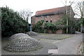
West End Sidings Estate
Built on the site of old Midland Railway sidings to the northwest of West Hampstead station. This is the entrance to the estate from Wayne Kirkum Way. The cobblestone igloos make unusual if slightly dull ornamentation.
Image: © Martin Addison
Taken: 11 Mar 2011
0.08 miles