IMAGES TAKEN NEAR TO
Southampton Road, LONDON, NW5 4JU
Introduction
This page details the photographs taken nearby to Southampton Road, NW5 4JU by members of the Geograph project.
The Geograph project started in 2005 with the aim of publishing, organising and preserving representative images for every square kilometre of Great Britain, Ireland and the Isle of Man.

There are currently over 7.5m images from over14,400 individuals and you can help contribute to the project by visiting https://www.geograph.org.uk
Image Map
Images are licensed for reuse under creativecommons.org/licenses/by-sa/2.0
Notes
- Clicking on the map will re-center to the selected point.
- The higher the marker number, the further away the image location is from the centre of the postcode.
Image Listing (279 Images Found)
Images are licensed for reuse under creativecommons.org/licenses/by-sa/2.0
Image
Details
Distance
3
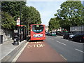
Bus stop and shelter on Southampton Road, London NW5
Image: © JThomas
Taken: 3 Sep 2016
0.02 miles
4
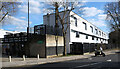
Gospel Oak : Dunboyne Road Estate
The modernist Dunboyne Road Estate is Grade II listed - built to designs by Neave Brown of the London Borough of Camden's Architects' Department - https://historicengland.org.uk/listing/the-list/list-entry/1393894?section=official-list-entry.
Image: © Jim Osley
Taken: 25 Mar 2016
0.02 miles
6
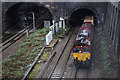
Belsize Tunnels
A class 66 (66088) stands outside the portals of Belsize Tunnels with a train of ballast for major engineering works being carried out to the west of Kentish Town Station. The extent of the work being carried out required the closure of St Pancras as well as the Thameslink route. As a result all services from the north were terminating at West Hampstead over the weekend of 31st January / 1st February 2015.
Image: © Martin Addison
Taken: 31 Jan 2015
0.03 miles
7
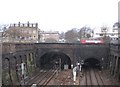
Gospel Oak: Southampton Road railway bridge and tunnel
When the Midland Railway extended their line south to St Pancras in the 1860s, they had to tunnel under Hampstead Hill. On the left here are the fast down and up lines while on the right are the slow down and up lines for suburban commuter traffic. For the slow lines the Southampton Road bridge is the eastern portal of the tunnel. However for the fast lines the Southampton Road bridge is in fact about 100 metres east of the eastern portal of that tunnel, with the space between them filled with a series of strengthening struts. As a consequence the railway is partially exposed to the sky between the two, which accounts for the partial daylight seen beyond the bridge along the left hand pair of tracks. The two openings are of markedly different sizes, probably because one is a tunnel and the other a bridge.
This photograph was taken from Image and in the opposite direction to Image
The bus is standing at the northbound bus stop in Southampton Road.
Image: © Nigel Cox
Taken: 14 Feb 2010
0.04 miles
9
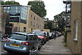
Housing estate off Southampton Road, Gospel Oak
The railway runs along the wall.
Image: © David Howard
Taken: 28 Apr 2020
0.04 miles