IMAGES TAKEN NEAR TO
St. Thomas's Gardens, LONDON, NW5 4EX
Introduction
This page details the photographs taken nearby to St. Thomas's Gardens, NW5 4EX by members of the Geograph project.
The Geograph project started in 2005 with the aim of publishing, organising and preserving representative images for every square kilometre of Great Britain, Ireland and the Isle of Man.

There are currently over 7.5m images from over14,400 individuals and you can help contribute to the project by visiting https://www.geograph.org.uk
Image Map
Images are licensed for reuse under creativecommons.org/licenses/by-sa/2.0
Notes
- Clicking on the map will re-center to the selected point.
- The higher the marker number, the further away the image location is from the centre of the postcode.
Image Listing (325 Images Found)
Images are licensed for reuse under creativecommons.org/licenses/by-sa/2.0
Image
Details
Distance
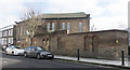
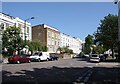
3
Malden Hall, Kentish Town
Home to the Thanet Youth and Community Centre.
Image: © Jim Osley
Taken: 29 Apr 2016
0.03 miles
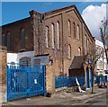
6
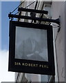
Faded sign for the Sir Robert Peel public house
Image: © JThomas
Taken: 3 Sep 2016
0.07 miles
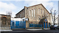
7
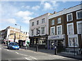
The Sir Robert Peel public house
On Malden Road.
Image: © JThomas
Taken: 3 Sep 2016
0.08 miles
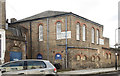
10
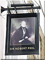
Sign for The Sir Robert Peel, Malden Road / Queen's Crescent, NW5
See Image
Image: © Mike Quinn
Taken: 7 Aug 2009
0.08 miles