IMAGES TAKEN NEAR TO
Burghley Road, LONDON, NW5 1UJ
Introduction
This page details the photographs taken nearby to Burghley Road, NW5 1UJ by members of the Geograph project.
The Geograph project started in 2005 with the aim of publishing, organising and preserving representative images for every square kilometre of Great Britain, Ireland and the Isle of Man.

There are currently over 7.5m images from over14,400 individuals and you can help contribute to the project by visiting https://www.geograph.org.uk
Image Map
Images are licensed for reuse under creativecommons.org/licenses/by-sa/2.0
Notes
- Clicking on the map will re-center to the selected point.
- The higher the marker number, the further away the image location is from the centre of the postcode.
Image Listing (201 Images Found)
Images are licensed for reuse under creativecommons.org/licenses/by-sa/2.0
Image
Details
Distance
1

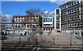
View of the Sixth Form Centre of Acland Burghley School
Acland Burghley School was one of hundreds of buildings across London participating in Open House Weekend, due to its distinctive 1960s brutalist architecture. Looking northeast.
Image: © Robert Lamb
Taken: 21 Sep 2019
0.02 miles
2

View of the Sixth Form Centre of Acland Burghley School
Looking northeast.
Image: © Robert Lamb
Taken: 21 Sep 2019
0.02 miles
3

View of Dartmouth Park Hill from Acland Burghley School
Looking northeast.
Image: © Robert Lamb
Taken: 21 Sep 2019
0.02 miles
4

View of Dartmouth Park Hill from Acland Burghley School #2
Looking northeast.
Image: © Robert Lamb
Taken: 21 Sep 2019
0.03 miles
5
Acland Burghley school, Tufnell Park
Built between 1963 and 1966 to the designs of architects Howell Killick Partridge & Amis.
Image: © Jim Osley
Taken: 25 Mar 2016
0.03 miles
6

View of the main entrance of Acland Burghley School
The ramp up the entrance conceals and carries school staff and pupils over an electricity substation. Looking northewest.
Image: © Robert Lamb
Taken: 21 Sep 2019
0.03 miles
7
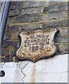
Old Boundary Marker by Dartmouth Hill Road, Highgate and Muswell Hill Parish
Parish Boundary Marker by the UC road, in parish of Highgate and Muswell Hill (Islington District), Dartmouth Park Hill N19, attached to first floor wall of No 6 (take-away), East side of road..
Surveyed
Milestone Society National ID: MX_SMI01pb.
Image: © Milestone Society
Taken: Unknown
0.03 miles
8
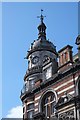
Cupola and clock, "The Boston" public house
Traditionally favoured by the local Irish community "The Boston" is a Grade II listed grand late Victorian public house and music venue, built to the designs of architects Thorpe and Furniss. Architectural description at this http://list.english-heritage.org.uk/resultsingle.aspx?uid=1195647.
Image: © Jim Osley
Taken: 25 Mar 2016
0.03 miles
9

View of a building in Acland Burghley School
Looking northeast.
Image: © Robert Lamb
Taken: 21 Sep 2019
0.04 miles
10

View of solar panels on the roof of Acland Burghley School
Looking north.
Image: © Robert Lamb
Taken: 21 Sep 2019
0.04 miles