IMAGES TAKEN NEAR TO
Church End, LONDON, NW4 4JX
Introduction
This page details the photographs taken nearby to Church End, NW4 4JX by members of the Geograph project.
The Geograph project started in 2005 with the aim of publishing, organising and preserving representative images for every square kilometre of Great Britain, Ireland and the Isle of Man.

There are currently over 7.5m images from over14,400 individuals and you can help contribute to the project by visiting https://www.geograph.org.uk
Image Map
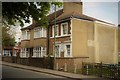
Images are licensed for reuse under creativecommons.org/licenses/by-sa/2.0
Notes
- Clicking on the map will re-center to the selected point.
- The higher the marker number, the further away the image location is from the centre of the postcode.
Image Listing (283 Images Found)
Images are licensed for reuse under creativecommons.org/licenses/by-sa/2.0
Image
Details
Distance
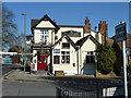
2
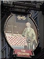
Sign for The Chequers, Church End, NW4
See Image
Image: © Mike Quinn
Taken: 17 Jan 2012
0.02 miles
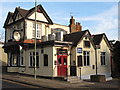
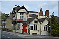
5
The Chequers, Hendon
On the corner of Church End and Prince of Wales Close.
Image: © Robin Webster
Taken: 19 Mar 2011
0.03 miles
7
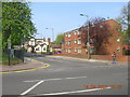
Church End at the Junction with Church Road, London NW4
Image: © Robin Sones
Taken: 14 Apr 2007
0.04 miles

9
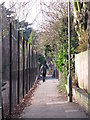
Path between Sunny Gardens Road and Church Terrace, NW4
Image: © Mike Quinn
Taken: 17 Jan 2012
0.05 miles
10
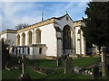
The Church of St. Mary, Church End, NW4 (2)
Image: © Mike Quinn
Taken: 17 Jan 2012
0.05 miles